You are here: Home > Network List > US - United States National Seismic Network Stations List
> Station EGMT Eagleton, Montana, USA > Earthquake Result Viewer
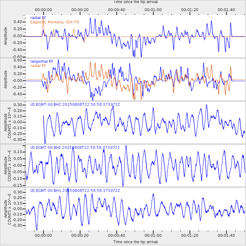
EGMT Eagleton, Montana, USA - Earthquake Result Viewer
*The percent match for this event was below the threshold and hence no stack was calculated.
| Earthquake location: |
Kuril Islands |
| Earthquake latitude/longitude: |
48.2/153.6 |
| Earthquake time(UTC): |
2015/08/08 (220) 22:47:37 GMT |
| Earthquake Depth: |
150 km |
| Earthquake Magnitude: |
4.2 mb |
| Earthquake Catalog/Contributor: |
ISC/ISC |
|
| Network: |
US United States National Seismic Network |
| Station: |
EGMT Eagleton, Montana, USA |
| Lat/Lon: |
48.02 N/109.75 W |
| Elevation: |
1055 m |
|
| Distance: |
60.1 deg |
| Az: |
50.317 deg |
| Baz: |
309.931 deg |
| Ray Param: |
$rayparam |
*The percent match for this event was below the threshold and hence was not used in the summary stack. |
|
| Radial Match: |
38.71355 % |
| Radial Bump: |
400 |
| Transverse Match: |
53.283234 % |
| Transverse Bump: |
400 |
| SOD ConfigId: |
7422571 |
| Insert Time: |
2019-04-20 06:14:00.033 +0000 |
| GWidth: |
2.5 |
| Max Bumps: |
400 |
| Tol: |
0.001 |
|
Signal To Noise
| Channel | StoN | STA | LTA |
| US:EGMT:00:BHZ:20150808T22:56:58.373972Z | 0.9231544 | 5.9123707E-8 | 6.40453E-8 |
| US:EGMT:00:BH1:20150808T22:56:58.373972Z | 0.8170208 | 1.1300506E-7 | 1.3831357E-7 |
| US:EGMT:00:BH2:20150808T22:56:58.373972Z | 0.92268217 | 1.1218063E-7 | 1.2158101E-7 |
| Arrivals |
| Ps | |
| PpPs | |
| PsPs/PpSs | |


