You are here: Home > Network List > CI - Caltech Regional Seismic Network Stations List
> Station DAN Danby, California, USA > Earthquake Result Viewer
DAN Danby, California, USA - Earthquake Result Viewer
| Earthquake location: |
Kermadec Islands Region |
| Earthquake latitude/longitude: |
-27.4/-176.1 |
| Earthquake time(UTC): |
2015/08/09 (221) 04:46:20 GMT |
| Earthquake Depth: |
10 km |
| Earthquake Magnitude: |
5.9 MWP |
| Earthquake Catalog/Contributor: |
NEIC PDE/NEIC COMCAT |
|
| Network: |
CI Caltech Regional Seismic Network |
| Station: |
DAN Danby, California, USA |
| Lat/Lon: |
34.64 N/115.38 W |
| Elevation: |
398 m |
|
| Distance: |
84.3 deg |
| Az: |
46.284 deg |
| Baz: |
231.193 deg |
| Ray Param: |
0.045586284 |
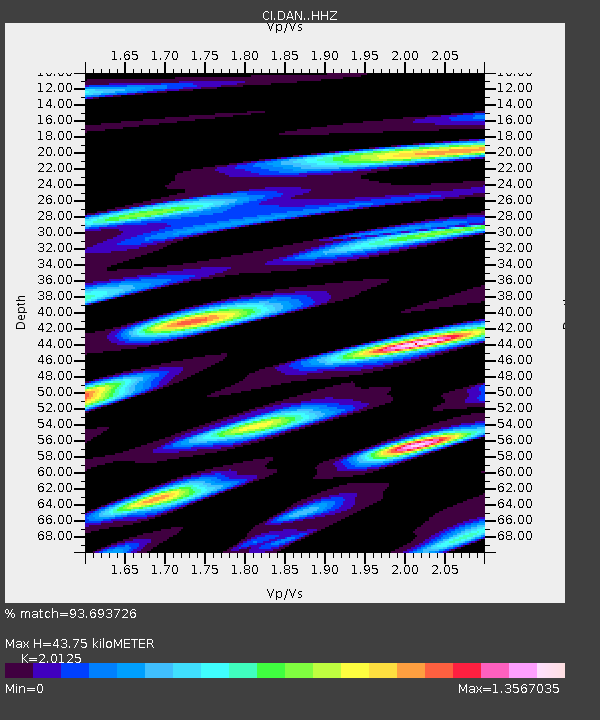
| Estimated Moho Depth: |
43.75 km |
| Estimated Crust Vp/Vs: |
2.01 |
| Assumed Crust Vp: |
6.276 km/s |
| Estimated Crust Vs: |
3.118 km/s |
| Estimated Crust Poisson's Ratio: |
0.34 |
|
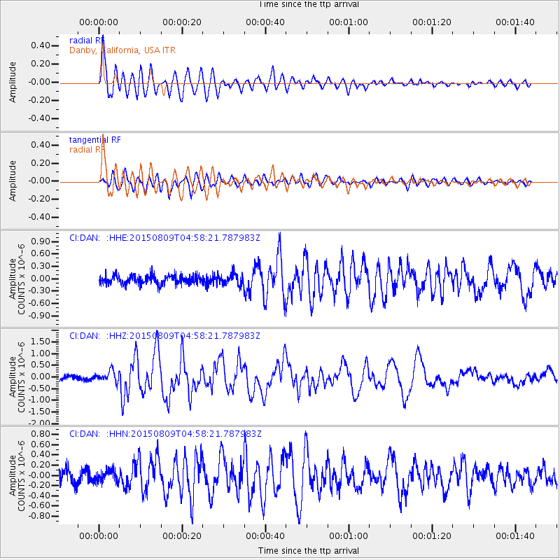
| Radial Match: |
93.693726 % |
| Radial Bump: |
400 |
| Transverse Match: |
80.66811 % |
| Transverse Bump: |
400 |
| SOD ConfigId: |
7422571 |
| Insert Time: |
2019-04-20 06:18:09.615 +0000 |
| GWidth: |
2.5 |
| Max Bumps: |
400 |
| Tol: |
0.001 |
|
Signal To Noise
| Channel | StoN | STA | LTA |
| CI:DAN: :HHZ:20150809T04:58:21.787983Z | 2.734875 | 2.3919014E-7 | 8.7459256E-8 |
| CI:DAN: :HHN:20150809T04:58:21.787983Z | 0.8415109 | 1.1912306E-7 | 1.4155854E-7 |
| CI:DAN: :HHE:20150809T04:58:21.787983Z | 1.2259246 | 1.3367404E-7 | 1.0903936E-7 |
| Arrivals |
| Ps | 7.2 SECOND |
| PpPs | 21 SECOND |
| PsPs/PpSs | 28 SECOND |


