You are here: Home > Network List > NN - Western Great Basin/Eastern Sierra Nevada Stations List
> Station KVN Kaiserville, Nevada w84gm > Earthquake Result Viewer
KVN Kaiserville, Nevada w84gm - Earthquake Result Viewer
| Earthquake location: |
Kermadec Islands Region |
| Earthquake latitude/longitude: |
-27.4/-176.1 |
| Earthquake time(UTC): |
2015/08/09 (221) 04:46:20 GMT |
| Earthquake Depth: |
10 km |
| Earthquake Magnitude: |
5.9 MWP |
| Earthquake Catalog/Contributor: |
NEIC PDE/NEIC COMCAT |
|
| Network: |
NN Western Great Basin/Eastern Sierra Nevada |
| Station: |
KVN Kaiserville, Nevada w84gm |
| Lat/Lon: |
39.05 N/118.10 W |
| Elevation: |
1829 m |
|
| Distance: |
85.4 deg |
| Az: |
41.486 deg |
| Baz: |
229.138 deg |
| Ray Param: |
0.044764668 |
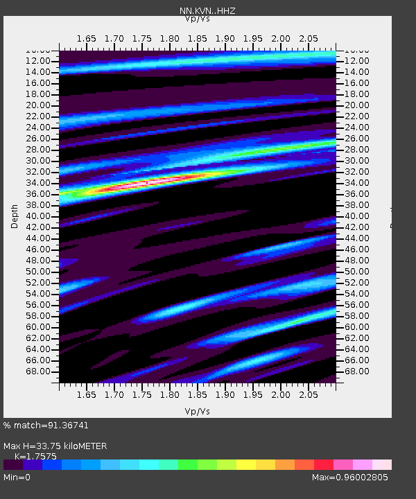
| Estimated Moho Depth: |
33.75 km |
| Estimated Crust Vp/Vs: |
1.76 |
| Assumed Crust Vp: |
6.279 km/s |
| Estimated Crust Vs: |
3.572 km/s |
| Estimated Crust Poisson's Ratio: |
0.26 |
|
| Radial Match: |
91.36741 % |
| Radial Bump: |
376 |
| Transverse Match: |
71.683136 % |
| Transverse Bump: |
400 |
| SOD ConfigId: |
7422571 |
| Insert Time: |
2019-04-20 06:20:00.077 +0000 |
| GWidth: |
2.5 |
| Max Bumps: |
400 |
| Tol: |
0.001 |
|

Signal To Noise
| Channel | StoN | STA | LTA |
| NN:KVN: :HHZ:20150809T04:58:27.524983Z | 2.8456793 | 1.55375E-7 | 5.4600324E-8 |
| NN:KVN: :HHN:20150809T04:58:27.524983Z | 2.293659 | 9.420604E-8 | 4.107238E-8 |
| NN:KVN: :HHE:20150809T04:58:27.524983Z | 1.9203211 | 7.3486824E-8 | 3.8267988E-8 |
| Arrivals |
| Ps | 4.2 SECOND |
| PpPs | 14 SECOND |
| PsPs/PpSs | 19 SECOND |


