You are here: Home > Network List > TA - USArray Transportable Network (new EarthScope stations) Stations List
> Station MSTX Muleshoe, TX, USA > Earthquake Result Viewer
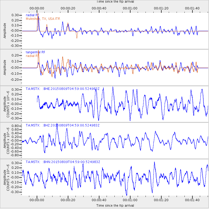
MSTX Muleshoe, TX, USA - Earthquake Result Viewer
*The percent match for this event was below the threshold and hence no stack was calculated.
| Earthquake location: |
Kermadec Islands Region |
| Earthquake latitude/longitude: |
-27.4/-176.1 |
| Earthquake time(UTC): |
2015/08/09 (221) 04:46:20 GMT |
| Earthquake Depth: |
10 km |
| Earthquake Magnitude: |
5.9 MWP |
| Earthquake Catalog/Contributor: |
NEIC PDE/NEIC COMCAT |
|
| Network: |
TA USArray Transportable Network (new EarthScope stations) |
| Station: |
MSTX Muleshoe, TX, USA |
| Lat/Lon: |
33.97 N/102.77 W |
| Elevation: |
1167 m |
|
| Distance: |
92.4 deg |
| Az: |
52.831 deg |
| Baz: |
238.473 deg |
| Ray Param: |
$rayparam |
*The percent match for this event was below the threshold and hence was not used in the summary stack. |
|
| Radial Match: |
68.69852 % |
| Radial Bump: |
400 |
| Transverse Match: |
61.62435 % |
| Transverse Bump: |
400 |
| SOD ConfigId: |
7422571 |
| Insert Time: |
2019-04-20 06:21:38.358 +0000 |
| GWidth: |
2.5 |
| Max Bumps: |
400 |
| Tol: |
0.001 |
|
Signal To Noise
| Channel | StoN | STA | LTA |
| TA:MSTX: :BHZ:20150809T04:59:00.524983Z | 4.701855 | 2.2018673E-7 | 4.6829758E-8 |
| TA:MSTX: :BHN:20150809T04:59:00.524983Z | 1.183164 | 7.9003144E-8 | 6.677278E-8 |
| TA:MSTX: :BHE:20150809T04:59:00.524983Z | 1.9108319 | 1.1072761E-7 | 5.794733E-8 |
| Arrivals |
| Ps | |
| PpPs | |
| PsPs/PpSs | |


