You are here: Home > Network List > US - United States National Seismic Network Stations List
> Station MSO Missoula, Montana, USA > Earthquake Result Viewer
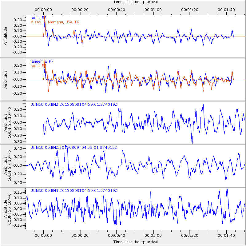
MSO Missoula, Montana, USA - Earthquake Result Viewer
*The percent match for this event was below the threshold and hence no stack was calculated.
| Earthquake location: |
Kermadec Islands Region |
| Earthquake latitude/longitude: |
-27.4/-176.1 |
| Earthquake time(UTC): |
2015/08/09 (221) 04:46:20 GMT |
| Earthquake Depth: |
10 km |
| Earthquake Magnitude: |
5.9 MWP |
| Earthquake Catalog/Contributor: |
NEIC PDE/NEIC COMCAT |
|
| Network: |
US United States National Seismic Network |
| Station: |
MSO Missoula, Montana, USA |
| Lat/Lon: |
46.83 N/113.94 W |
| Elevation: |
1264 m |
|
| Distance: |
92.7 deg |
| Az: |
37.433 deg |
| Baz: |
231.905 deg |
| Ray Param: |
$rayparam |
*The percent match for this event was below the threshold and hence was not used in the summary stack. |
|
| Radial Match: |
59.855125 % |
| Radial Bump: |
400 |
| Transverse Match: |
64.204056 % |
| Transverse Bump: |
400 |
| SOD ConfigId: |
7422571 |
| Insert Time: |
2019-04-20 06:22:26.498 +0000 |
| GWidth: |
2.5 |
| Max Bumps: |
400 |
| Tol: |
0.001 |
|
Signal To Noise
| Channel | StoN | STA | LTA |
| US:MSO:00:BHZ:20150809T04:59:01.974019Z | 1.4587634 | 9.738172E-8 | 6.675635E-8 |
| US:MSO:00:BH1:20150809T04:59:01.974019Z | 0.47874007 | 3.2777496E-8 | 6.8466164E-8 |
| US:MSO:00:BH2:20150809T04:59:01.974019Z | 0.80254084 | 5.336481E-8 | 6.649482E-8 |
| Arrivals |
| Ps | |
| PpPs | |
| PsPs/PpSs | |


