You are here: Home > Network List > US - United States National Seismic Network Stations List
> Station AHID Auburn Hatchery, Idaho, USA > Earthquake Result Viewer
AHID Auburn Hatchery, Idaho, USA - Earthquake Result Viewer
| Earthquake location: |
Tonga Islands |
| Earthquake latitude/longitude: |
-15.2/-173.2 |
| Earthquake time(UTC): |
2015/04/07 (097) 00:46:18 GMT |
| Earthquake Depth: |
10 km |
| Earthquake Magnitude: |
5.8 MB |
| Earthquake Catalog/Contributor: |
NEIC PDE/NEIC ALERT |
|
| Network: |
US United States National Seismic Network |
| Station: |
AHID Auburn Hatchery, Idaho, USA |
| Lat/Lon: |
42.77 N/111.10 W |
| Elevation: |
1960 m |
|
| Distance: |
81.0 deg |
| Az: |
41.226 deg |
| Baz: |
239.772 deg |
| Ray Param: |
0.047884792 |
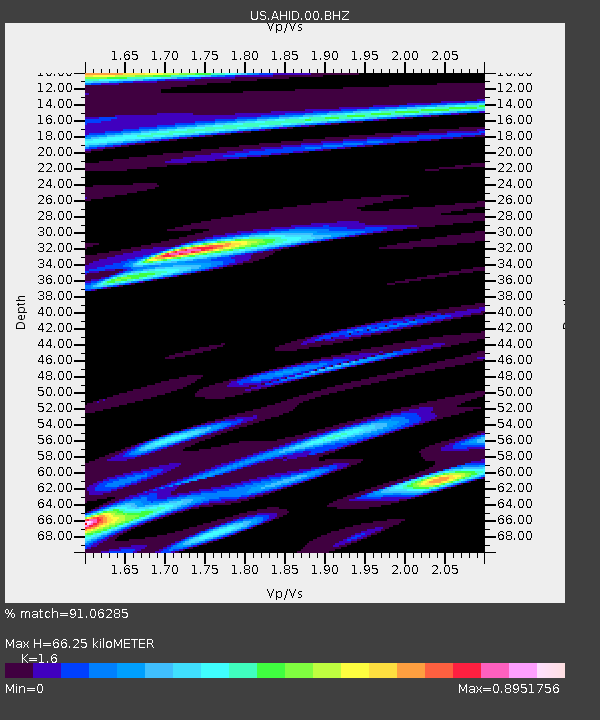
| Estimated Moho Depth: |
66.25 km |
| Estimated Crust Vp/Vs: |
1.60 |
| Assumed Crust Vp: |
6.207 km/s |
| Estimated Crust Vs: |
3.879 km/s |
| Estimated Crust Poisson's Ratio: |
0.18 |
|
| Radial Match: |
91.06285 % |
| Radial Bump: |
400 |
| Transverse Match: |
92.02357 % |
| Transverse Bump: |
400 |
| SOD ConfigId: |
872571 |
| Insert Time: |
2015-04-21 01:06:50.470 +0000 |
| GWidth: |
2.5 |
| Max Bumps: |
400 |
| Tol: |
0.001 |
|
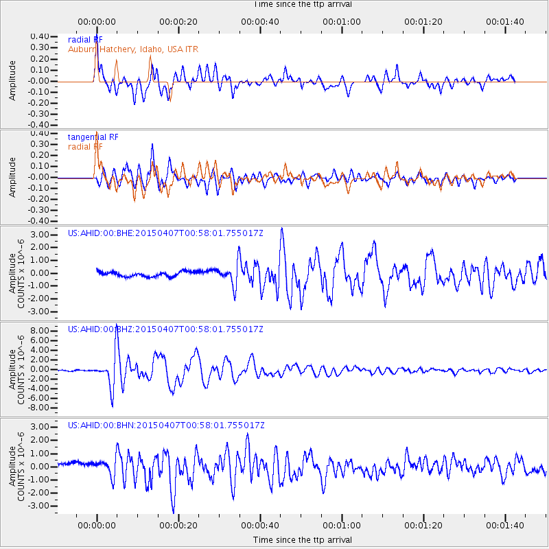
Signal To Noise
| Channel | StoN | STA | LTA |
| US:AHID:00:BHZ:20150407T00:58:01.755017Z | 41.862747 | 3.4577677E-6 | 8.259772E-8 |
| US:AHID:00:BHN:20150407T00:58:01.755017Z | 3.1572874 | 6.41605E-7 | 2.0321401E-7 |
| US:AHID:00:BHE:20150407T00:58:01.755017Z | 4.5225344 | 8.3825887E-7 | 1.8535157E-7 |
| Arrivals |
| Ps | 6.6 SECOND |
| PpPs | 27 SECOND |
| PsPs/PpSs | 34 SECOND |


