You are here: Home > Network List > IU - Global Seismograph Network (GSN - IRIS/USGS) Stations List
> Station INCN Inchon, Republic of Korea > Earthquake Result Viewer
INCN Inchon, Republic of Korea - Earthquake Result Viewer
| Earthquake location: |
South Of Fiji Islands |
| Earthquake latitude/longitude: |
-24.1/-177.0 |
| Earthquake time(UTC): |
1996/04/16 (107) 00:30:54 GMT |
| Earthquake Depth: |
111 km |
| Earthquake Magnitude: |
6.4 MB, 6.8 MS, 7.1 UNKNOWN, 7.1 MW |
| Earthquake Catalog/Contributor: |
WHDF/NEIC |
|
| Network: |
IU Global Seismograph Network (GSN - IRIS/USGS) |
| Station: |
INCN Inchon, Republic of Korea |
| Lat/Lon: |
37.48 N/126.63 E |
| Elevation: |
420 m |
|
| Distance: |
80.9 deg |
| Az: |
317.901 deg |
| Baz: |
129.611 deg |
| Ray Param: |
0.04768296 |
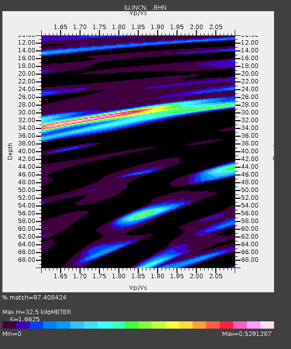
| Estimated Moho Depth: |
32.5 km |
| Estimated Crust Vp/Vs: |
1.66 |
| Assumed Crust Vp: |
6.459 km/s |
| Estimated Crust Vs: |
3.885 km/s |
| Estimated Crust Poisson's Ratio: |
0.22 |
|
| Radial Match: |
97.408424 % |
| Radial Bump: |
270 |
| Transverse Match: |
83.729935 % |
| Transverse Bump: |
400 |
| SOD ConfigId: |
6273 |
| Insert Time: |
2010-03-04 15:05:05.378 +0000 |
| GWidth: |
2.5 |
| Max Bumps: |
400 |
| Tol: |
0.001 |
|
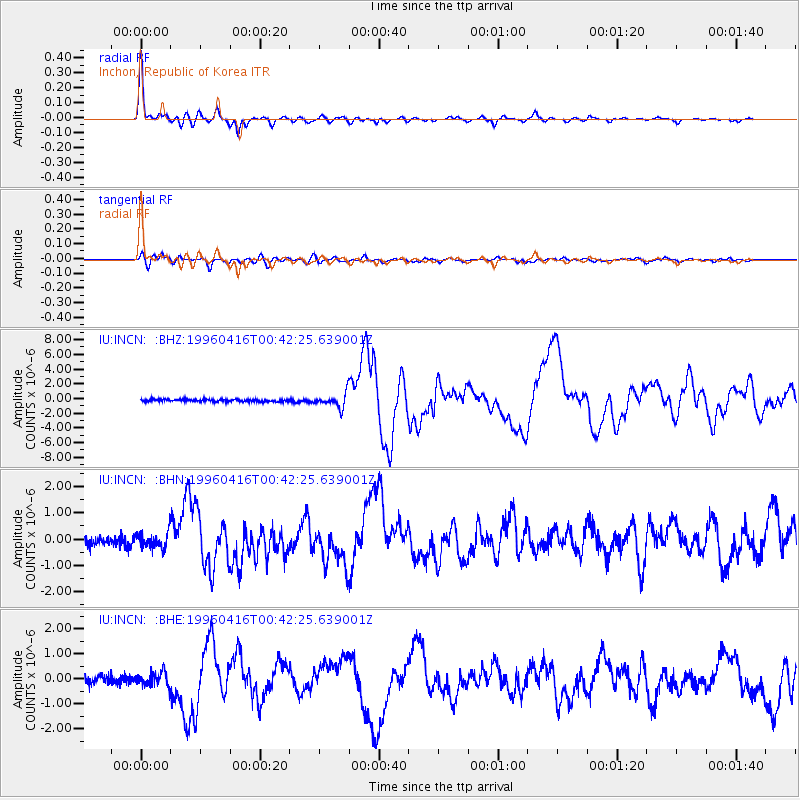
Signal To Noise
| Channel | StoN | STA | LTA |
| IU:INCN: :BHN:19960416T00:42:25.639001Z | 1.6528658 | 2.927071E-7 | 1.7709068E-7 |
| IU:INCN: :BHE:19960416T00:42:25.639001Z | 1.641879 | 2.8270895E-7 | 1.7218622E-7 |
| IU:INCN: :BHZ:19960416T00:42:25.639001Z | 6.1639547 | 9.471326E-7 | 1.5365664E-7 |
| Arrivals |
| Ps | 3.4 SECOND |
| PpPs | 13 SECOND |
| PsPs/PpSs | 16 SECOND |


