You are here: Home > Network List > AV - Alaska Volcano Observatory Stations List
> Station MAPS Pakushin Southeast, Makushin Volcano, Alaska > Earthquake Result Viewer
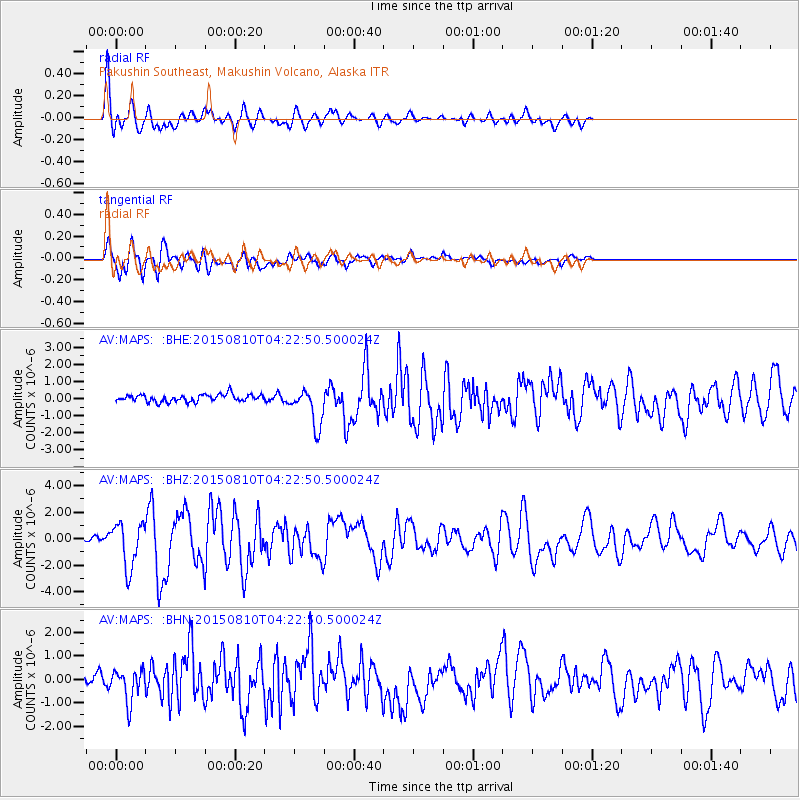
MAPS Pakushin Southeast, Makushin Volcano, Alaska - Earthquake Result Viewer
*The percent match for this event was below the threshold and hence no stack was calculated.
| Earthquake location: |
Solomon Islands |
| Earthquake latitude/longitude: |
-9.4/158.0 |
| Earthquake time(UTC): |
2015/08/10 (222) 04:12:14 GMT |
| Earthquake Depth: |
10 km |
| Earthquake Magnitude: |
6.9 MO |
| Earthquake Catalog/Contributor: |
NEIC PDE/NEIC ALERT |
|
| Network: |
AV Alaska Volcano Observatory |
| Station: |
MAPS Pakushin Southeast, Makushin Volcano, Alaska |
| Lat/Lon: |
53.81 N/166.94 W |
| Elevation: |
333 m |
|
| Distance: |
69.6 deg |
| Az: |
21.316 deg |
| Baz: |
217.218 deg |
| Ray Param: |
$rayparam |
*The percent match for this event was below the threshold and hence was not used in the summary stack. |
|
| Radial Match: |
87.83067 % |
| Radial Bump: |
400 |
| Transverse Match: |
71.418045 % |
| Transverse Bump: |
400 |
| SOD ConfigId: |
7422571 |
| Insert Time: |
2019-04-20 06:45:59.882 +0000 |
| GWidth: |
2.5 |
| Max Bumps: |
400 |
| Tol: |
0.001 |
|
Signal To Noise
| Channel | StoN | STA | LTA |
| AV:MAPS: :BHZ:20150810T04:22:50.500024Z | 6.212356 | 1.6741257E-6 | 2.6948322E-7 |
| AV:MAPS: :BHN:20150810T04:22:50.500024Z | 3.1756926 | 6.7506016E-7 | 2.1257101E-7 |
| AV:MAPS: :BHE:20150810T04:22:50.500024Z | 5.413011 | 1.1485946E-6 | 2.1219145E-7 |
| Arrivals |
| Ps | |
| PpPs | |
| PsPs/PpSs | |


