You are here: Home > Network List > US - United States National Seismic Network Stations List
> Station WVOR Wild Horse Valley, Oregon, USA > Earthquake Result Viewer
WVOR Wild Horse Valley, Oregon, USA - Earthquake Result Viewer
| Earthquake location: |
Tonga Islands |
| Earthquake latitude/longitude: |
-15.2/-173.2 |
| Earthquake time(UTC): |
2015/04/07 (097) 00:46:18 GMT |
| Earthquake Depth: |
10 km |
| Earthquake Magnitude: |
5.8 MB |
| Earthquake Catalog/Contributor: |
NEIC PDE/NEIC ALERT |
|
| Network: |
US United States National Seismic Network |
| Station: |
WVOR Wild Horse Valley, Oregon, USA |
| Lat/Lon: |
42.43 N/118.64 W |
| Elevation: |
1344 m |
|
| Distance: |
76.2 deg |
| Az: |
38.415 deg |
| Baz: |
234.128 deg |
| Ray Param: |
0.051174548 |
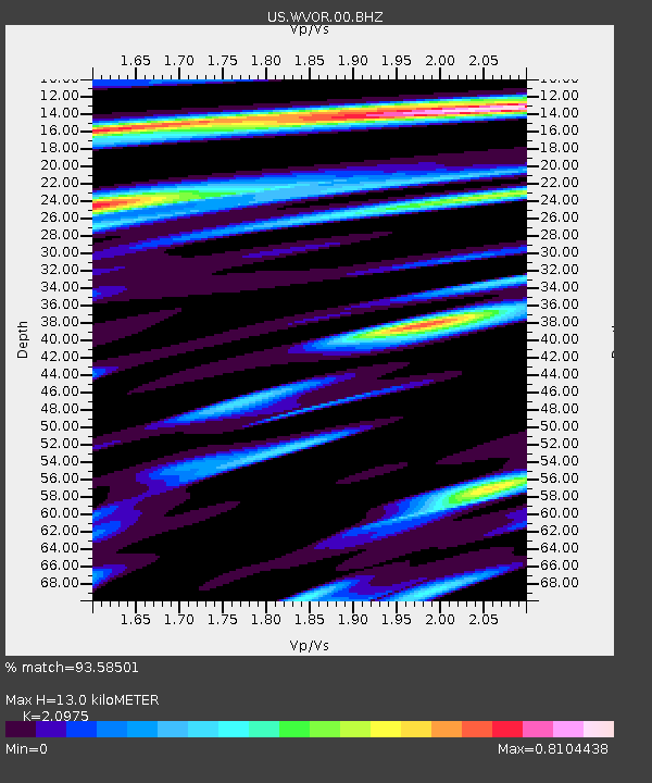
| Estimated Moho Depth: |
13.0 km |
| Estimated Crust Vp/Vs: |
2.10 |
| Assumed Crust Vp: |
6.279 km/s |
| Estimated Crust Vs: |
2.993 km/s |
| Estimated Crust Poisson's Ratio: |
0.35 |
|
| Radial Match: |
93.58501 % |
| Radial Bump: |
374 |
| Transverse Match: |
88.635124 % |
| Transverse Bump: |
400 |
| SOD ConfigId: |
872571 |
| Insert Time: |
2015-04-21 01:09:02.091 +0000 |
| GWidth: |
2.5 |
| Max Bumps: |
400 |
| Tol: |
0.001 |
|
Signal To Noise
| Channel | StoN | STA | LTA |
| US:WVOR:00:BHZ:20150407T00:57:35.149976Z | 32.50734 | 3.561809E-6 | 1.0956939E-7 |
| US:WVOR:00:BH1:20150407T00:57:35.149976Z | 4.7322197 | 6.439956E-7 | 1.3608744E-7 |
| US:WVOR:00:BH2:20150407T00:57:35.149976Z | 5.073081 | 8.197443E-7 | 1.6158707E-7 |
| Arrivals |
| Ps | 2.3 SECOND |
| PpPs | 6.3 SECOND |
| PsPs/PpSs | 8.6 SECOND |


