You are here: Home > Network List > IC - New China Digital Seismograph Network Stations List
> Station KMI Kunming, Yunnan Province, China > Earthquake Result Viewer
KMI Kunming, Yunnan Province, China - Earthquake Result Viewer
| Earthquake location: |
Solomon Islands |
| Earthquake latitude/longitude: |
-9.4/158.0 |
| Earthquake time(UTC): |
2015/08/10 (222) 04:12:14 GMT |
| Earthquake Depth: |
10 km |
| Earthquake Magnitude: |
6.9 MO |
| Earthquake Catalog/Contributor: |
NEIC PDE/NEIC ALERT |
|
| Network: |
IC New China Digital Seismograph Network |
| Station: |
KMI Kunming, Yunnan Province, China |
| Lat/Lon: |
25.12 N/102.74 E |
| Elevation: |
1975 m |
|
| Distance: |
63.8 deg |
| Az: |
303.889 deg |
| Baz: |
115.355 deg |
| Ray Param: |
0.059337575 |
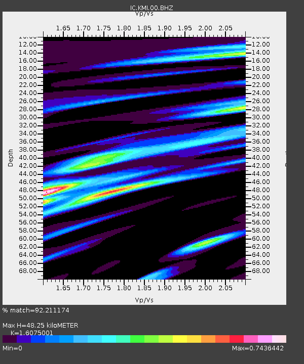
| Estimated Moho Depth: |
48.25 km |
| Estimated Crust Vp/Vs: |
1.61 |
| Assumed Crust Vp: |
6.247 km/s |
| Estimated Crust Vs: |
3.886 km/s |
| Estimated Crust Poisson's Ratio: |
0.18 |
|
| Radial Match: |
92.211174 % |
| Radial Bump: |
400 |
| Transverse Match: |
84.77148 % |
| Transverse Bump: |
400 |
| SOD ConfigId: |
7422571 |
| Insert Time: |
2019-04-20 06:47:43.928 +0000 |
| GWidth: |
2.5 |
| Max Bumps: |
400 |
| Tol: |
0.001 |
|
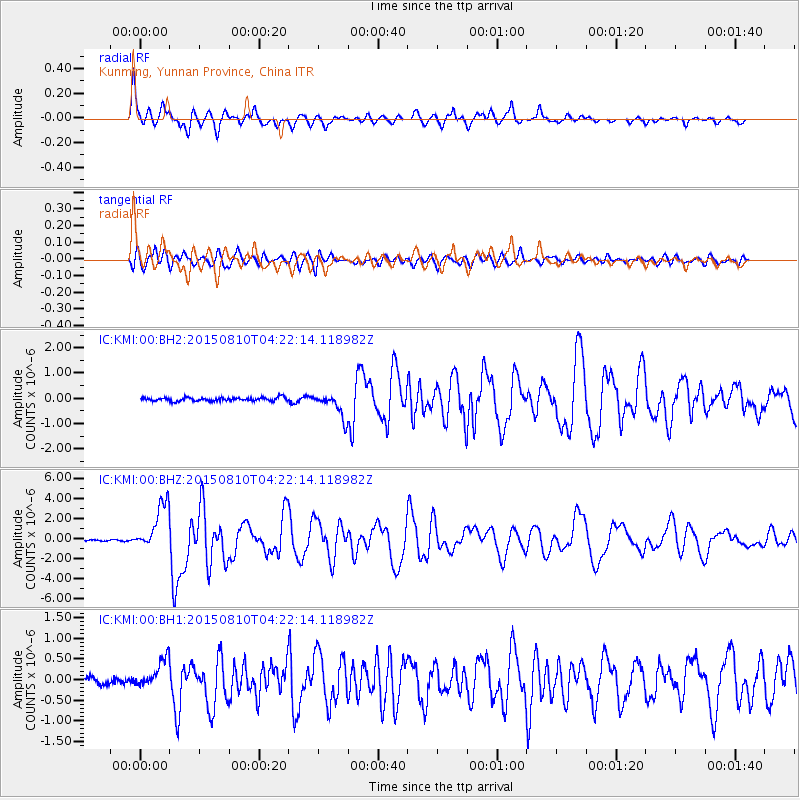
Signal To Noise
| Channel | StoN | STA | LTA |
| IC:KMI:00:BHZ:20150810T04:22:14.118982Z | 29.190708 | 2.3504494E-6 | 8.0520465E-8 |
| IC:KMI:00:BH1:20150810T04:22:14.118982Z | 4.0214243 | 3.5665042E-7 | 8.8687585E-8 |
| IC:KMI:00:BH2:20150810T04:22:14.118982Z | 9.622954 | 7.486001E-7 | 7.779317E-8 |
| Arrivals |
| Ps | 4.9 SECOND |
| PpPs | 19 SECOND |
| PsPs/PpSs | 24 SECOND |


