You are here: Home > Network List > NN - Western Great Basin/Eastern Sierra Nevada Stations List
> Station YER Yerington, Nevada w84gm > Earthquake Result Viewer
YER Yerington, Nevada w84gm - Earthquake Result Viewer
| Earthquake location: |
Solomon Islands |
| Earthquake latitude/longitude: |
-9.4/158.0 |
| Earthquake time(UTC): |
2015/08/10 (222) 04:12:14 GMT |
| Earthquake Depth: |
10 km |
| Earthquake Magnitude: |
6.9 MO |
| Earthquake Catalog/Contributor: |
NEIC PDE/NEIC ALERT |
|
| Network: |
NN Western Great Basin/Eastern Sierra Nevada |
| Station: |
YER Yerington, Nevada w84gm |
| Lat/Lon: |
38.99 N/119.24 W |
| Elevation: |
1857 m |
|
| Distance: |
90.3 deg |
| Az: |
50.639 deg |
| Baz: |
258.224 deg |
| Ray Param: |
0.0416859 |
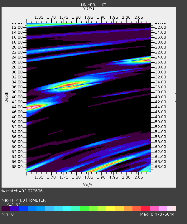
| Estimated Moho Depth: |
44.0 km |
| Estimated Crust Vp/Vs: |
1.62 |
| Assumed Crust Vp: |
6.279 km/s |
| Estimated Crust Vs: |
3.876 km/s |
| Estimated Crust Poisson's Ratio: |
0.19 |
|
| Radial Match: |
82.872696 % |
| Radial Bump: |
400 |
| Transverse Match: |
80.57435 % |
| Transverse Bump: |
400 |
| SOD ConfigId: |
7422571 |
| Insert Time: |
2019-04-20 06:48:42.902 +0000 |
| GWidth: |
2.5 |
| Max Bumps: |
400 |
| Tol: |
0.001 |
|

Signal To Noise
| Channel | StoN | STA | LTA |
| NN:YER: :HHZ:20150810T04:24:41.959985Z | 9.843844 | 5.3265506E-7 | 5.4110473E-8 |
| NN:YER: :HHN:20150810T04:24:41.959985Z | 0.95879227 | 8.69717E-8 | 9.070964E-8 |
| NN:YER: :HHE:20150810T04:24:41.959985Z | 2.9425614 | 6.3399614E-7 | 2.1545723E-7 |
| Arrivals |
| Ps | 4.4 SECOND |
| PpPs | 18 SECOND |
| PsPs/PpSs | 22 SECOND |


