You are here: Home > Network List > UU - University of Utah Regional Network Stations List
> Station JLU Jordanelle, UT, USA > Earthquake Result Viewer
JLU Jordanelle, UT, USA - Earthquake Result Viewer
| Earthquake location: |
Tonga Islands |
| Earthquake latitude/longitude: |
-15.2/-173.2 |
| Earthquake time(UTC): |
2015/04/07 (097) 00:46:18 GMT |
| Earthquake Depth: |
10 km |
| Earthquake Magnitude: |
5.8 MB |
| Earthquake Catalog/Contributor: |
NEIC PDE/NEIC ALERT |
|
| Network: |
UU University of Utah Regional Network |
| Station: |
JLU Jordanelle, UT, USA |
| Lat/Lon: |
40.60 N/111.45 W |
| Elevation: |
2285 m |
|
| Distance: |
79.7 deg |
| Az: |
42.988 deg |
| Baz: |
239.835 deg |
| Ray Param: |
0.04878121 |
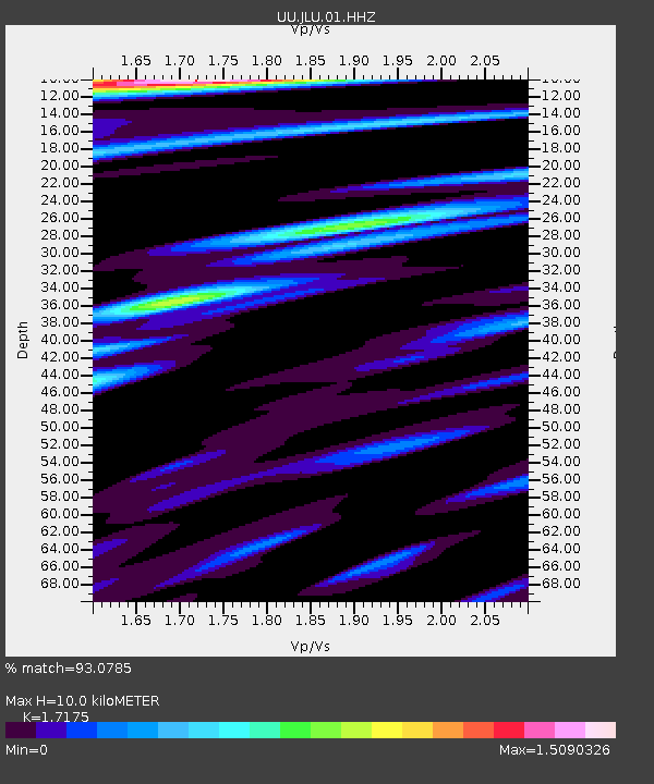
| Estimated Moho Depth: |
10.0 km |
| Estimated Crust Vp/Vs: |
1.72 |
| Assumed Crust Vp: |
6.155 km/s |
| Estimated Crust Vs: |
3.584 km/s |
| Estimated Crust Poisson's Ratio: |
0.24 |
|
| Radial Match: |
93.0785 % |
| Radial Bump: |
400 |
| Transverse Match: |
87.67032 % |
| Transverse Bump: |
400 |
| SOD ConfigId: |
872571 |
| Insert Time: |
2015-04-21 01:09:27.773 +0000 |
| GWidth: |
2.5 |
| Max Bumps: |
400 |
| Tol: |
0.001 |
|

Signal To Noise
| Channel | StoN | STA | LTA |
| UU:JLU:01:HHZ:20150407T00:57:54.698987Z | 36.642265 | 7.963739E-8 | 2.173375E-9 |
| UU:JLU:01:HHN:20150407T00:57:54.698987Z | 5.8863525 | 1.5562808E-8 | 2.6438796E-9 |
| UU:JLU:01:HHE:20150407T00:57:54.698987Z | 5.712477 | 2.1984793E-8 | 3.8485566E-9 |
| Arrivals |
| Ps | 1.2 SECOND |
| PpPs | 4.3 SECOND |
| PsPs/PpSs | 5.5 SECOND |


