You are here: Home > Network List > UU - University of Utah Regional Network Stations List
> Station KNB Kanab, UT, USA > Earthquake Result Viewer
KNB Kanab, UT, USA - Earthquake Result Viewer
| Earthquake location: |
Tonga Islands |
| Earthquake latitude/longitude: |
-15.2/-173.2 |
| Earthquake time(UTC): |
2015/04/07 (097) 00:46:18 GMT |
| Earthquake Depth: |
10 km |
| Earthquake Magnitude: |
5.8 MB |
| Earthquake Catalog/Contributor: |
NEIC PDE/NEIC ALERT |
|
| Network: |
UU University of Utah Regional Network |
| Station: |
KNB Kanab, UT, USA |
| Lat/Lon: |
37.02 N/112.82 W |
| Elevation: |
1715 m |
|
| Distance: |
77.0 deg |
| Az: |
45.59 deg |
| Baz: |
239.505 deg |
| Ray Param: |
0.050639313 |
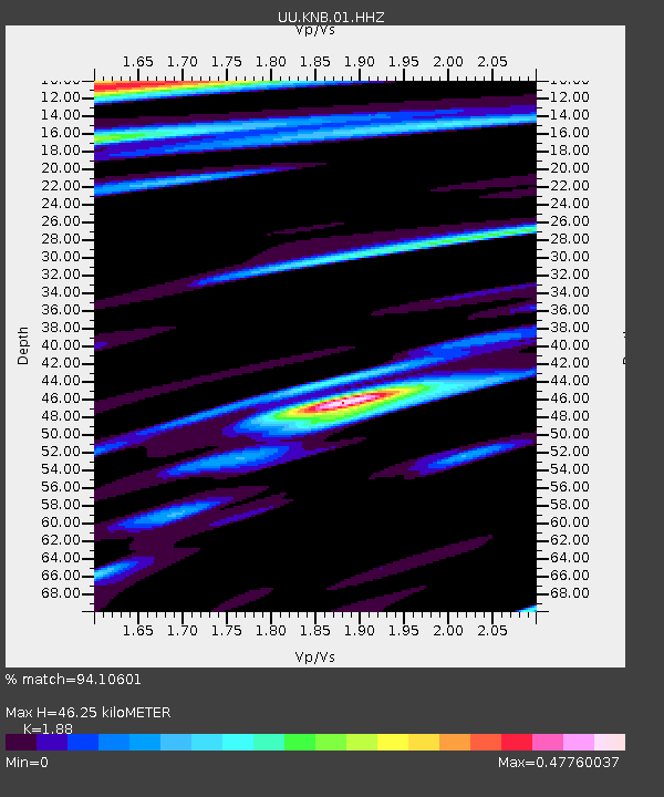
| Estimated Moho Depth: |
46.25 km |
| Estimated Crust Vp/Vs: |
1.88 |
| Assumed Crust Vp: |
6.194 km/s |
| Estimated Crust Vs: |
3.295 km/s |
| Estimated Crust Poisson's Ratio: |
0.30 |
|
| Radial Match: |
94.10601 % |
| Radial Bump: |
368 |
| Transverse Match: |
91.25297 % |
| Transverse Bump: |
400 |
| SOD ConfigId: |
872571 |
| Insert Time: |
2015-04-21 01:09:30.335 +0000 |
| GWidth: |
2.5 |
| Max Bumps: |
400 |
| Tol: |
0.001 |
|
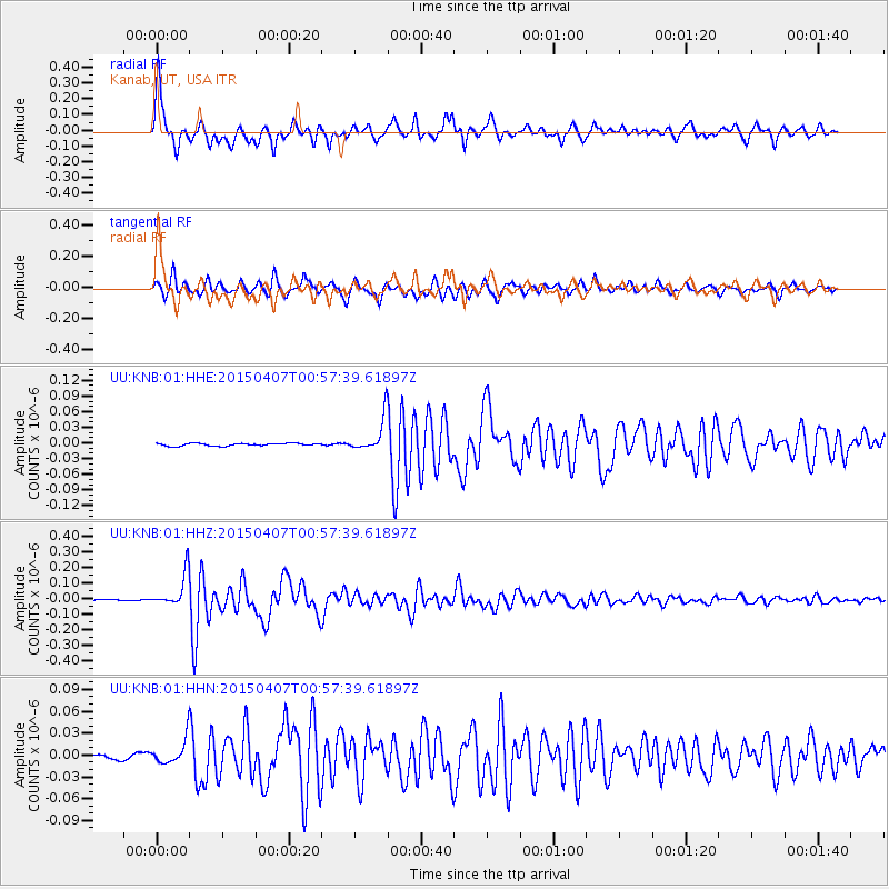
Signal To Noise
| Channel | StoN | STA | LTA |
| UU:KNB:01:HHZ:20150407T00:57:39.61897Z | 32.01159 | 1.05055285E-7 | 3.281789E-9 |
| UU:KNB:01:HHN:20150407T00:57:39.61897Z | 4.461703 | 1.648466E-8 | 3.6947014E-9 |
| UU:KNB:01:HHE:20150407T00:57:39.61897Z | 12.384636 | 3.1555945E-8 | 2.5479914E-9 |
| Arrivals |
| Ps | 6.8 SECOND |
| PpPs | 21 SECOND |
| PsPs/PpSs | 28 SECOND |


