You are here: Home > Network List > TA - USArray Transportable Network (new EarthScope stations) Stations List
> Station K04D Chiloquin, OR, USA > Earthquake Result Viewer
K04D Chiloquin, OR, USA - Earthquake Result Viewer
| Earthquake location: |
Solomon Islands |
| Earthquake latitude/longitude: |
-9.4/158.0 |
| Earthquake time(UTC): |
2015/08/10 (222) 04:12:14 GMT |
| Earthquake Depth: |
10 km |
| Earthquake Magnitude: |
6.9 MO |
| Earthquake Catalog/Contributor: |
NEIC PDE/NEIC ALERT |
|
| Network: |
TA USArray Transportable Network (new EarthScope stations) |
| Station: |
K04D Chiloquin, OR, USA |
| Lat/Lon: |
42.62 N/121.75 W |
| Elevation: |
1315 m |
|
| Distance: |
89.2 deg |
| Az: |
46.676 deg |
| Baz: |
256.568 deg |
| Ray Param: |
0.042028464 |
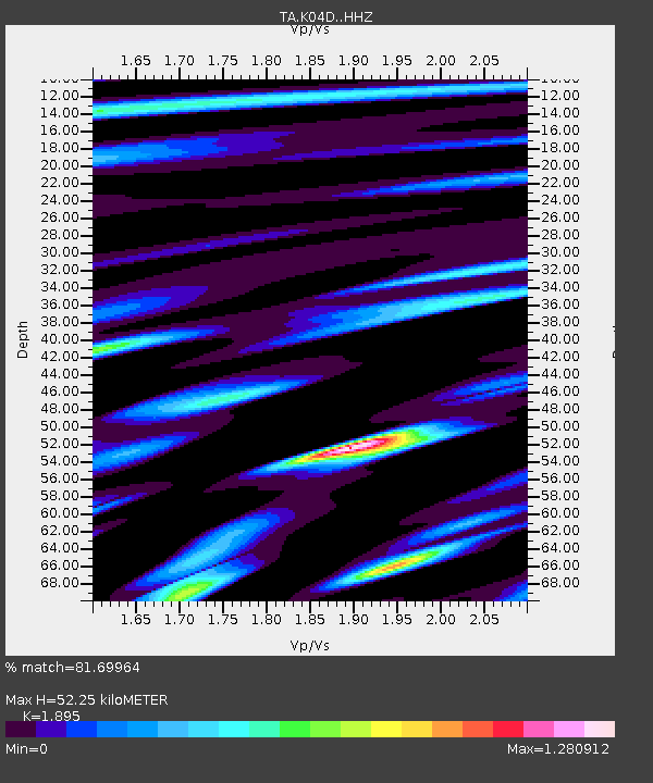
| Estimated Moho Depth: |
52.25 km |
| Estimated Crust Vp/Vs: |
1.89 |
| Assumed Crust Vp: |
6.597 km/s |
| Estimated Crust Vs: |
3.482 km/s |
| Estimated Crust Poisson's Ratio: |
0.31 |
|
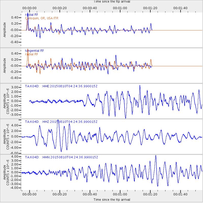
| Radial Match: |
81.69964 % |
| Radial Bump: |
400 |
| Transverse Match: |
85.20403 % |
| Transverse Bump: |
400 |
| SOD ConfigId: |
7422571 |
| Insert Time: |
2019-04-20 06:49:41.840 +0000 |
| GWidth: |
2.5 |
| Max Bumps: |
400 |
| Tol: |
0.001 |
|
Signal To Noise
| Channel | StoN | STA | LTA |
| TA:K04D: :HHZ:20150810T04:24:36.990015Z | 10.2298975 | 1.00047E-6 | 9.779864E-8 |
| TA:K04D: :HHN:20150810T04:24:36.990015Z | 1.5583835 | 1.8458397E-7 | 1.1844579E-7 |
| TA:K04D: :HHE:20150810T04:24:36.990015Z | 1.4457642 | 2.4324913E-7 | 1.6824953E-7 |
| Arrivals |
| Ps | 7.2 SECOND |
| PpPs | 22 SECOND |
| PsPs/PpSs | 30 SECOND |


