You are here: Home > Network List > UW - Pacific Northwest Regional Seismic Network Stations List
> Station LON Longmire CREST broad-band > Earthquake Result Viewer
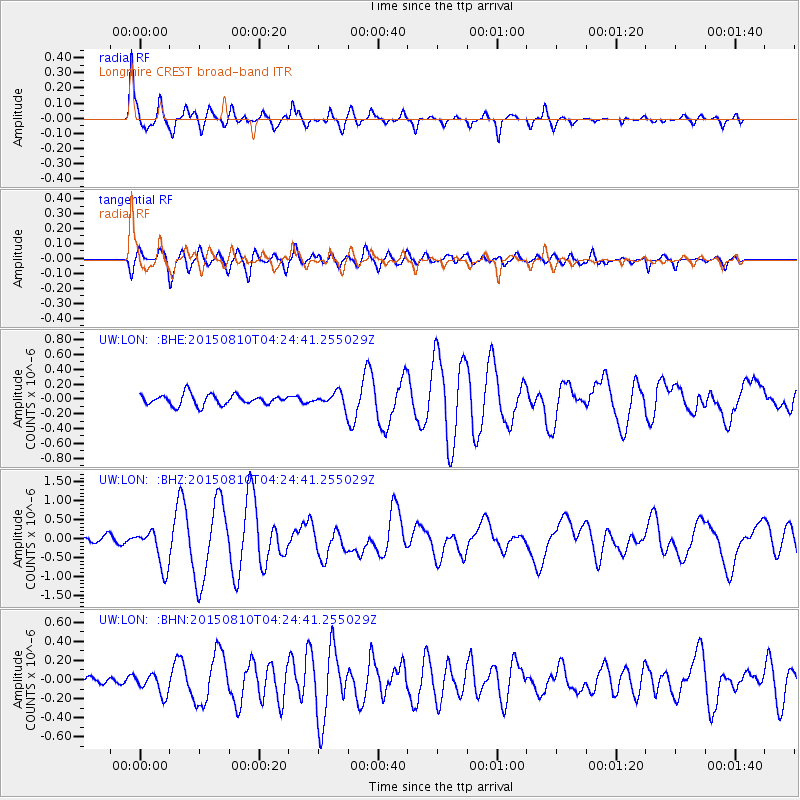
LON Longmire CREST broad-band - Earthquake Result Viewer
*The percent match for this event was below the threshold and hence no stack was calculated.
| Earthquake location: |
Solomon Islands |
| Earthquake latitude/longitude: |
-9.4/158.0 |
| Earthquake time(UTC): |
2015/08/10 (222) 04:12:14 GMT |
| Earthquake Depth: |
10 km |
| Earthquake Magnitude: |
6.9 MO |
| Earthquake Catalog/Contributor: |
NEIC PDE/NEIC ALERT |
|
| Network: |
UW Pacific Northwest Regional Seismic Network |
| Station: |
LON Longmire CREST broad-band |
| Lat/Lon: |
46.75 N/121.81 W |
| Elevation: |
853 m |
|
| Distance: |
90.1 deg |
| Az: |
42.654 deg |
| Baz: |
256.504 deg |
| Ray Param: |
$rayparam |
*The percent match for this event was below the threshold and hence was not used in the summary stack. |
|
| Radial Match: |
88.784744 % |
| Radial Bump: |
400 |
| Transverse Match: |
78.127655 % |
| Transverse Bump: |
400 |
| SOD ConfigId: |
7422571 |
| Insert Time: |
2019-04-20 06:50:53.054 +0000 |
| GWidth: |
2.5 |
| Max Bumps: |
400 |
| Tol: |
0.001 |
|
Signal To Noise
| Channel | StoN | STA | LTA |
| UW:LON: :BHZ:20150810T04:24:41.255029Z | 5.829762 | 5.212132E-7 | 8.9405574E-8 |
| UW:LON: :BHN:20150810T04:24:41.255029Z | 2.0214539 | 1.0888334E-7 | 5.386388E-8 |
| UW:LON: :BHE:20150810T04:24:41.255029Z | 2.8469589 | 2.0184885E-7 | 7.0899816E-8 |
| Arrivals |
| Ps | |
| PpPs | |
| PsPs/PpSs | |


