You are here: Home > Network List > XL12 - Hangay Dome, Mongolia Stations List
> Station HV31 HV31 > Earthquake Result Viewer
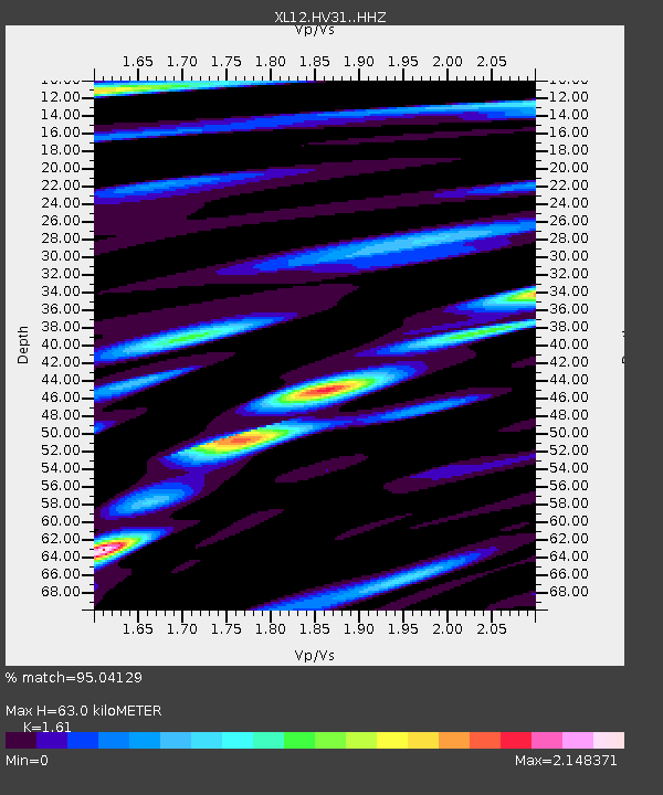
HV31 HV31 - Earthquake Result Viewer
| Earthquake location: |
Solomon Islands |
| Earthquake latitude/longitude: |
-9.4/158.0 |
| Earthquake time(UTC): |
2015/08/10 (222) 04:12:14 GMT |
| Earthquake Depth: |
10 km |
| Earthquake Magnitude: |
6.9 MO |
| Earthquake Catalog/Contributor: |
NEIC PDE/NEIC ALERT |
|
| Network: |
XL Hangay Dome, Mongolia |
| Station: |
HV31 HV31 |
| Lat/Lon: |
51.34 N/100.24 E |
| Elevation: |
1693 m |
|
| Distance: |
78.2 deg |
| Az: |
327.183 deg |
| Baz: |
121.51 deg |
| Ray Param: |
0.049791805 |
| Estimated Moho Depth: |
63.0 km |
| Estimated Crust Vp/Vs: |
1.61 |
| Assumed Crust Vp: |
6.419 km/s |
| Estimated Crust Vs: |
3.987 km/s |
| Estimated Crust Poisson's Ratio: |
0.19 |
|
| Radial Match: |
95.04129 % |
| Radial Bump: |
400 |
| Transverse Match: |
90.50888 % |
| Transverse Bump: |
400 |
| SOD ConfigId: |
7422571 |
| Insert Time: |
2019-04-20 06:52:23.942 +0000 |
| GWidth: |
2.5 |
| Max Bumps: |
400 |
| Tol: |
0.001 |
|

Signal To Noise
| Channel | StoN | STA | LTA |
| XL:HV31: :HHZ:20150810T04:23:41.079004Z | 54.73512 | 3.0656977E-6 | 5.6009704E-8 |
| XL:HV31: :HHN:20150810T04:23:41.079004Z | 6.681343 | 6.23605E-7 | 9.333527E-8 |
| XL:HV31: :HHE:20150810T04:23:41.079004Z | 10.954614 | 9.931202E-7 | 9.0657714E-8 |
| Arrivals |
| Ps | 6.2 SECOND |
| PpPs | 25 SECOND |
| PsPs/PpSs | 31 SECOND |


