You are here: Home > Network List > TA - USArray Transportable Network (new EarthScope stations) Stations List
> Station TPFO Pinon Flats, CA, USA > Earthquake Result Viewer
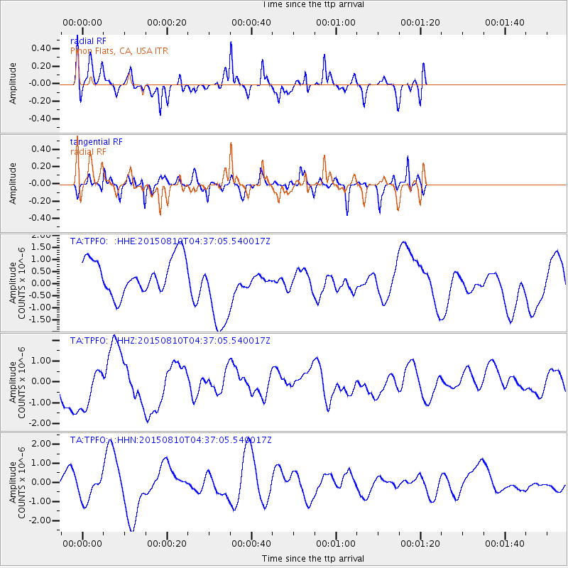
TPFO Pinon Flats, CA, USA - Earthquake Result Viewer
*The percent match for this event was below the threshold and hence no stack was calculated.
| Earthquake location: |
Solomon Islands |
| Earthquake latitude/longitude: |
-9.3/158.0 |
| Earthquake time(UTC): |
2015/08/10 (222) 04:24:31 GMT |
| Earthquake Depth: |
10 km |
| Earthquake Magnitude: |
5.7 MB |
| Earthquake Catalog/Contributor: |
NEIC PDE/NEIC COMCAT |
|
| Network: |
TA USArray Transportable Network (new EarthScope stations) |
| Station: |
TPFO Pinon Flats, CA, USA |
| Lat/Lon: |
33.61 N/116.45 W |
| Elevation: |
1275 m |
|
| Distance: |
91.4 deg |
| Az: |
56.342 deg |
| Baz: |
259.864 deg |
| Ray Param: |
$rayparam |
*The percent match for this event was below the threshold and hence was not used in the summary stack. |
|
| Radial Match: |
72.15619 % |
| Radial Bump: |
356 |
| Transverse Match: |
39.684296 % |
| Transverse Bump: |
286 |
| SOD ConfigId: |
7422571 |
| Insert Time: |
2019-04-20 06:57:17.311 +0000 |
| GWidth: |
2.5 |
| Max Bumps: |
400 |
| Tol: |
0.001 |
|
Signal To Noise
| Channel | StoN | STA | LTA |
| TA:TPFO: :HHZ:20150810T04:37:05.540017Z | 1.6986382 | 1.033149E-6 | 6.082219E-7 |
| TA:TPFO: :HHN:20150810T04:37:05.540017Z | 1.021882 | 7.317338E-7 | 7.160648E-7 |
| TA:TPFO: :HHE:20150810T04:37:05.540017Z | 2.4649255 | 1.7594089E-6 | 7.137777E-7 |
| Arrivals |
| Ps | |
| PpPs | |
| PsPs/PpSs | |


