You are here: Home > Network List > WY - Yellowstone Wyoming Seismic Network Stations List
> Station YTP The Promontory, YNP, WY, USA > Earthquake Result Viewer
YTP The Promontory, YNP, WY, USA - Earthquake Result Viewer
| Earthquake location: |
Tonga Islands |
| Earthquake latitude/longitude: |
-15.2/-173.2 |
| Earthquake time(UTC): |
2015/04/07 (097) 00:46:18 GMT |
| Earthquake Depth: |
10 km |
| Earthquake Magnitude: |
5.8 MB |
| Earthquake Catalog/Contributor: |
NEIC PDE/NEIC ALERT |
|
| Network: |
WY Yellowstone Wyoming Seismic Network |
| Station: |
YTP The Promontory, YNP, WY, USA |
| Lat/Lon: |
44.39 N/110.29 W |
| Elevation: |
2384 m |
|
| Distance: |
82.3 deg |
| Az: |
40.103 deg |
| Baz: |
240.169 deg |
| Ray Param: |
0.046954893 |
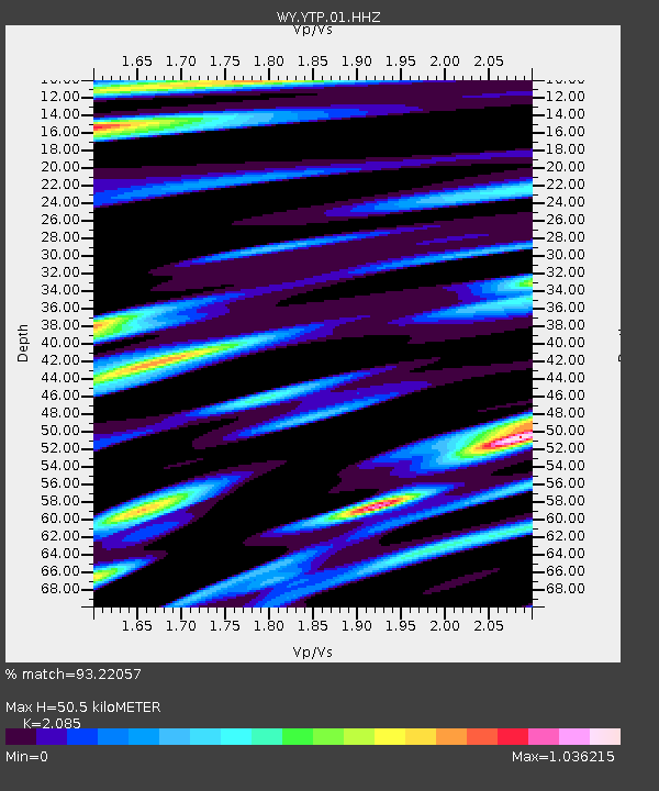
| Estimated Moho Depth: |
50.5 km |
| Estimated Crust Vp/Vs: |
2.09 |
| Assumed Crust Vp: |
6.35 km/s |
| Estimated Crust Vs: |
3.046 km/s |
| Estimated Crust Poisson's Ratio: |
0.35 |
|
| Radial Match: |
93.22057 % |
| Radial Bump: |
335 |
| Transverse Match: |
92.64589 % |
| Transverse Bump: |
331 |
| SOD ConfigId: |
872571 |
| Insert Time: |
2015-04-21 01:10:44.154 +0000 |
| GWidth: |
2.5 |
| Max Bumps: |
400 |
| Tol: |
0.001 |
|

Signal To Noise
| Channel | StoN | STA | LTA |
| WY:YTP:01:HHZ:20150407T00:58:08.71803Z | 42.231388 | 8.432951E-8 | 1.9968442E-9 |
| WY:YTP:01:HHN:20150407T00:58:08.71803Z | 5.5797095 | 1.7235534E-8 | 3.0889662E-9 |
| WY:YTP:01:HHE:20150407T00:58:08.71803Z | 4.009665 | 1.812212E-8 | 4.51961E-9 |
| Arrivals |
| Ps | 8.8 SECOND |
| PpPs | 24 SECOND |
| PsPs/PpSs | 33 SECOND |


