You are here: Home > Network List > GS - US Geological Survey Networks Stations List
> Station KAN10 Keim Farm, Anthony, KS, USA > Earthquake Result Viewer
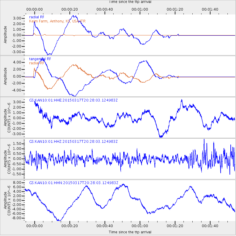
KAN10 Keim Farm, Anthony, KS, USA - Earthquake Result Viewer
*The percent match for this event was below the threshold and hence no stack was calculated.
| Earthquake location: |
Fiji Islands Region |
| Earthquake latitude/longitude: |
-17.8/-178.6 |
| Earthquake time(UTC): |
2015/03/17 (076) 20:16:19 GMT |
| Earthquake Depth: |
556 km |
| Earthquake Magnitude: |
5.5 MWW, 5.6 MWC, 5.6 MWB |
| Earthquake Catalog/Contributor: |
NEIC PDE/NEIC COMCAT |
|
| Network: |
GS US Geological Survey Networks |
| Station: |
KAN10 Keim Farm, Anthony, KS, USA |
| Lat/Lon: |
37.12 N/98.10 W |
| Elevation: |
417 m |
|
| Distance: |
93.3 deg |
| Az: |
52.141 deg |
| Baz: |
250.215 deg |
| Ray Param: |
$rayparam |
*The percent match for this event was below the threshold and hence was not used in the summary stack. |
|
| Radial Match: |
46.96418 % |
| Radial Bump: |
400 |
| Transverse Match: |
54.921154 % |
| Transverse Bump: |
400 |
| SOD ConfigId: |
872571 |
| Insert Time: |
2015-04-22 18:55:45.422 +0000 |
| GWidth: |
2.5 |
| Max Bumps: |
400 |
| Tol: |
0.001 |
|
Signal To Noise
| Channel | StoN | STA | LTA |
| GS:KAN10:01:HHZ:20150317T20:28:03.124983Z | 0.8125068 | 4.2954645E-7 | 5.286681E-7 |
| GS:KAN10:01:HHN:20150317T20:28:03.124983Z | 0.82212776 | 1.7664923E-6 | 2.1486835E-6 |
| GS:KAN10:01:HHE:20150317T20:28:03.124983Z | 0.40617272 | 4.2234396E-7 | 1.0398137E-6 |
| Arrivals |
| Ps | |
| PpPs | |
| PsPs/PpSs | |


