You are here: Home > Network List > AZ - ANZA Regional Network Stations List
> Station LVA2 AZ.LVA2 > Earthquake Result Viewer
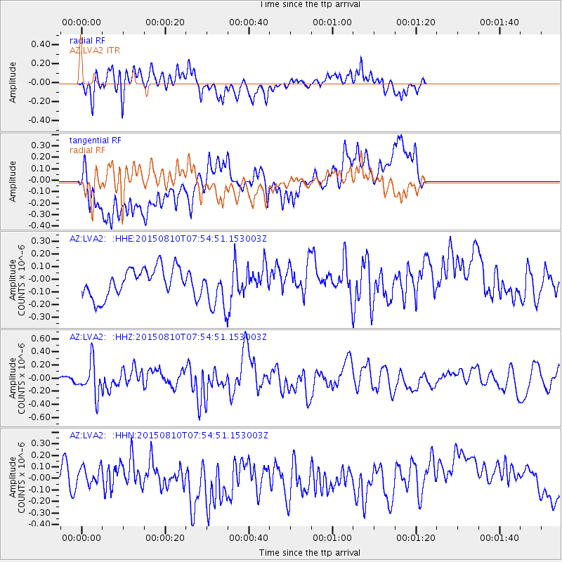
LVA2 AZ.LVA2 - Earthquake Result Viewer
*The percent match for this event was below the threshold and hence no stack was calculated.
| Earthquake location: |
Tonga Islands |
| Earthquake latitude/longitude: |
-19.6/-174.8 |
| Earthquake time(UTC): |
2015/08/10 (222) 07:43:38 GMT |
| Earthquake Depth: |
57 km |
| Earthquake Magnitude: |
5.6 MB |
| Earthquake Catalog/Contributor: |
NEIC PDE/NEIC ALERT |
|
| Network: |
AZ ANZA Regional Network |
| Station: |
LVA2 AZ.LVA2 |
| Lat/Lon: |
33.35 N/116.56 W |
| Elevation: |
1435 m |
|
| Distance: |
76.6 deg |
| Az: |
47.035 deg |
| Baz: |
235.499 deg |
| Ray Param: |
$rayparam |
*The percent match for this event was below the threshold and hence was not used in the summary stack. |
|
| Radial Match: |
66.83327 % |
| Radial Bump: |
400 |
| Transverse Match: |
42.936993 % |
| Transverse Bump: |
400 |
| SOD ConfigId: |
7422571 |
| Insert Time: |
2019-04-20 07:00:27.858 +0000 |
| GWidth: |
2.5 |
| Max Bumps: |
400 |
| Tol: |
0.001 |
|
Signal To Noise
| Channel | StoN | STA | LTA |
| AZ:LVA2: :HHZ:20150810T07:54:51.153003Z | 4.084259 | 2.619833E-7 | 6.414463E-8 |
| AZ:LVA2: :HHN:20150810T07:54:51.153003Z | 0.32439998 | 7.091503E-8 | 2.1860369E-7 |
| AZ:LVA2: :HHE:20150810T07:54:51.153003Z | 1.6742864 | 1.8507998E-7 | 1.1054261E-7 |
| Arrivals |
| Ps | |
| PpPs | |
| PsPs/PpSs | |


