You are here: Home > Network List > CI - Caltech Regional Seismic Network Stations List
> Station MUR Murrieta > Earthquake Result Viewer
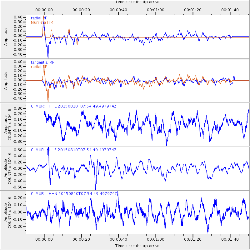
MUR Murrieta - Earthquake Result Viewer
*The percent match for this event was below the threshold and hence no stack was calculated.
| Earthquake location: |
Tonga Islands |
| Earthquake latitude/longitude: |
-19.6/-174.8 |
| Earthquake time(UTC): |
2015/08/10 (222) 07:43:38 GMT |
| Earthquake Depth: |
57 km |
| Earthquake Magnitude: |
5.6 MB |
| Earthquake Catalog/Contributor: |
NEIC PDE/NEIC ALERT |
|
| Network: |
CI Caltech Regional Seismic Network |
| Station: |
MUR Murrieta |
| Lat/Lon: |
33.60 N/117.20 W |
| Elevation: |
562 m |
|
| Distance: |
76.3 deg |
| Az: |
46.515 deg |
| Baz: |
235.029 deg |
| Ray Param: |
$rayparam |
*The percent match for this event was below the threshold and hence was not used in the summary stack. |
|
| Radial Match: |
75.891075 % |
| Radial Bump: |
400 |
| Transverse Match: |
62.445282 % |
| Transverse Bump: |
400 |
| SOD ConfigId: |
7422571 |
| Insert Time: |
2019-04-20 07:01:28.127 +0000 |
| GWidth: |
2.5 |
| Max Bumps: |
400 |
| Tol: |
0.001 |
|
Signal To Noise
| Channel | StoN | STA | LTA |
| CI:MUR: :HHZ:20150810T07:54:49.497974Z | 2.3681996 | 2.928204E-7 | 1.2364684E-7 |
| CI:MUR: :HHN:20150810T07:54:49.497974Z | 1.0094354 | 7.3656565E-8 | 7.2968085E-8 |
| CI:MUR: :HHE:20150810T07:54:49.497974Z | 0.8422634 | 1.09807864E-7 | 1.3037236E-7 |
| Arrivals |
| Ps | |
| PpPs | |
| PsPs/PpSs | |


