You are here: Home > Network List > CI - Caltech Regional Seismic Network Stations List
> Station SMM Simmler, CA, USA > Earthquake Result Viewer
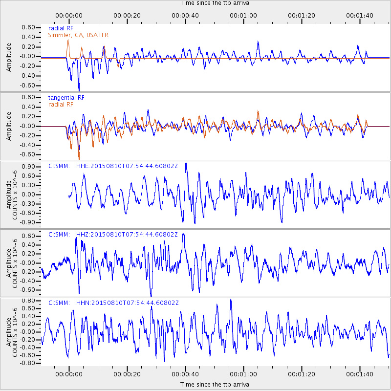
SMM Simmler, CA, USA - Earthquake Result Viewer
*The percent match for this event was below the threshold and hence no stack was calculated.
| Earthquake location: |
Tonga Islands |
| Earthquake latitude/longitude: |
-19.6/-174.8 |
| Earthquake time(UTC): |
2015/08/10 (222) 07:43:38 GMT |
| Earthquake Depth: |
57 km |
| Earthquake Magnitude: |
5.6 MB |
| Earthquake Catalog/Contributor: |
NEIC PDE/NEIC ALERT |
|
| Network: |
CI Caltech Regional Seismic Network |
| Station: |
SMM Simmler, CA, USA |
| Lat/Lon: |
35.31 N/120.00 W |
| Elevation: |
599 m |
|
| Distance: |
75.4 deg |
| Az: |
43.684 deg |
| Baz: |
232.758 deg |
| Ray Param: |
$rayparam |
*The percent match for this event was below the threshold and hence was not used in the summary stack. |
|
| Radial Match: |
60.1705 % |
| Radial Bump: |
400 |
| Transverse Match: |
51.196625 % |
| Transverse Bump: |
400 |
| SOD ConfigId: |
7422571 |
| Insert Time: |
2019-04-20 07:01:36.589 +0000 |
| GWidth: |
2.5 |
| Max Bumps: |
400 |
| Tol: |
0.001 |
|
Signal To Noise
| Channel | StoN | STA | LTA |
| CI:SMM: :HHZ:20150810T07:54:44.60802Z | 1.9875466 | 3.0330662E-7 | 1.5260353E-7 |
| CI:SMM: :HHN:20150810T07:54:44.60802Z | 2.241412 | 4.0180845E-7 | 1.7926578E-7 |
| CI:SMM: :HHE:20150810T07:54:44.60802Z | 1.226188 | 3.3809505E-7 | 2.7572858E-7 |
| Arrivals |
| Ps | |
| PpPs | |
| PsPs/PpSs | |


