You are here: Home > Network List > UW - Pacific Northwest Regional Seismic Network Stations List
> Station OMAK Colville Reservation, Omak, WA, USA > Earthquake Result Viewer
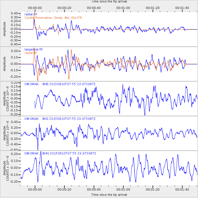
OMAK Colville Reservation, Omak, WA, USA - Earthquake Result Viewer
*The percent match for this event was below the threshold and hence no stack was calculated.
| Earthquake location: |
Tonga Islands |
| Earthquake latitude/longitude: |
-19.6/-174.8 |
| Earthquake time(UTC): |
2015/08/10 (222) 07:43:38 GMT |
| Earthquake Depth: |
57 km |
| Earthquake Magnitude: |
5.6 MB |
| Earthquake Catalog/Contributor: |
NEIC PDE/NEIC ALERT |
|
| Network: |
UW Pacific Northwest Regional Seismic Network |
| Station: |
OMAK Colville Reservation, Omak, WA, USA |
| Lat/Lon: |
48.36 N/119.33 W |
| Elevation: |
696 m |
|
| Distance: |
83.8 deg |
| Az: |
33.552 deg |
| Baz: |
231.364 deg |
| Ray Param: |
$rayparam |
*The percent match for this event was below the threshold and hence was not used in the summary stack. |
|
| Radial Match: |
75.68456 % |
| Radial Bump: |
400 |
| Transverse Match: |
60.182438 % |
| Transverse Bump: |
400 |
| SOD ConfigId: |
7422571 |
| Insert Time: |
2019-04-20 07:06:27.872 +0000 |
| GWidth: |
2.5 |
| Max Bumps: |
400 |
| Tol: |
0.001 |
|
Signal To Noise
| Channel | StoN | STA | LTA |
| UW:OMAK: :BHZ:20150810T07:55:29.973987Z | 2.2824116 | 1.98415E-7 | 8.6932175E-8 |
| UW:OMAK: :BHN:20150810T07:55:29.973987Z | 1.9884326 | 1.3332115E-7 | 6.704836E-8 |
| UW:OMAK: :BHE:20150810T07:55:29.973987Z | 1.1133271 | 6.594937E-8 | 5.9236292E-8 |
| Arrivals |
| Ps | |
| PpPs | |
| PsPs/PpSs | |


