You are here: Home > Network List > IU - Global Seismograph Network (GSN - IRIS/USGS) Stations List
> Station INCN Inchon, Republic of Korea > Earthquake Result Viewer
INCN Inchon, Republic of Korea - Earthquake Result Viewer
| Earthquake location: |
Mindanao, Philippines |
| Earthquake latitude/longitude: |
6.9/126.6 |
| Earthquake time(UTC): |
2001/01/01 (001) 06:57:04 GMT |
| Earthquake Depth: |
33 km |
| Earthquake Magnitude: |
6.4 MB, 7.2 MS, 7.5 MW, 7.3 ME |
| Earthquake Catalog/Contributor: |
WHDF/NEIC |
|
| Network: |
IU Global Seismograph Network (GSN - IRIS/USGS) |
| Station: |
INCN Inchon, Republic of Korea |
| Lat/Lon: |
37.48 N/126.63 E |
| Elevation: |
420 m |
|
| Distance: |
30.4 deg |
| Az: |
0.085 deg |
| Baz: |
180.106 deg |
| Ray Param: |
0.07929916 |
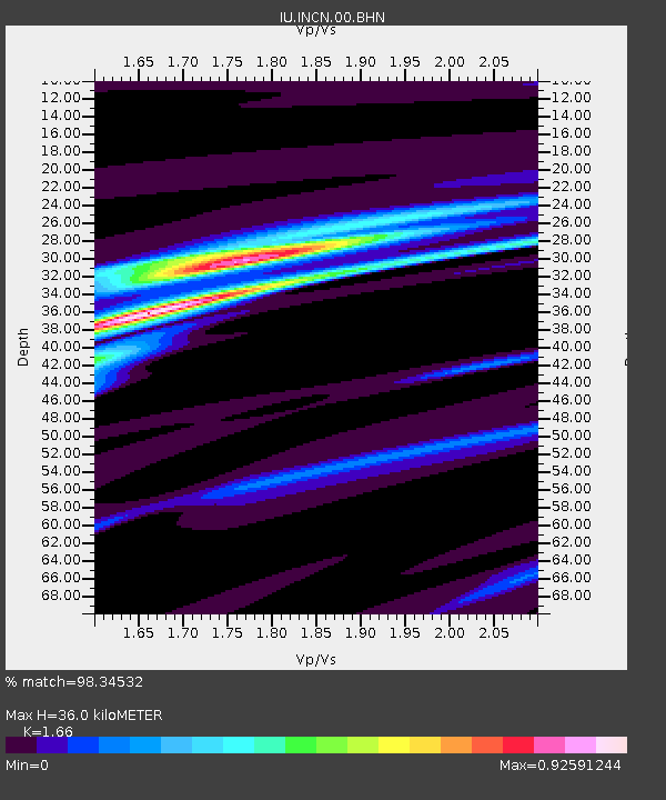
| Estimated Moho Depth: |
36.0 km |
| Estimated Crust Vp/Vs: |
1.66 |
| Assumed Crust Vp: |
6.459 km/s |
| Estimated Crust Vs: |
3.891 km/s |
| Estimated Crust Poisson's Ratio: |
0.22 |
|
| Radial Match: |
98.34532 % |
| Radial Bump: |
221 |
| Transverse Match: |
77.64032 % |
| Transverse Bump: |
400 |
| SOD ConfigId: |
3744 |
| Insert Time: |
2010-03-04 15:12:40.737 +0000 |
| GWidth: |
2.5 |
| Max Bumps: |
400 |
| Tol: |
0.001 |
|
Signal To Noise
| Channel | StoN | STA | LTA |
| IU:INCN:00:BHN:20010101T07:02:43.40999Z | 2.483816 | 1.5283814E-6 | 6.1533603E-7 |
| IU:INCN:00:BHE:20010101T07:02:43.40999Z | 1.4104809 | 3.5768684E-7 | 2.5359213E-7 |
| IU:INCN:00:BHZ:20010101T07:02:43.40999Z | 4.264166 | 2.6905457E-6 | 6.3096644E-7 |
| Arrivals |
| Ps | 4.0 SECOND |
| PpPs | 14 SECOND |
| PsPs/PpSs | 18 SECOND |


