You are here: Home > Network List > DK - Danish Seismological Network Stations List
> Station ILULI Ilulissat, Greenland > Earthquake Result Viewer
ILULI Ilulissat, Greenland - Earthquake Result Viewer
| Earthquake location: |
Afghanistan-Tajikistan Bord Reg. |
| Earthquake latitude/longitude: |
36.5/71.2 |
| Earthquake time(UTC): |
2015/08/10 (222) 10:05:25 GMT |
| Earthquake Depth: |
223 km |
| Earthquake Magnitude: |
5.7 MB |
| Earthquake Catalog/Contributor: |
NEIC PDE/NEIC COMCAT |
|
| Network: |
DK Danish Seismological Network |
| Station: |
ILULI Ilulissat, Greenland |
| Lat/Lon: |
69.21 N/51.10 W |
| Elevation: |
54 m |
|
| Distance: |
66.4 deg |
| Az: |
340.781 deg |
| Baz: |
47.969 deg |
| Ray Param: |
0.056950655 |
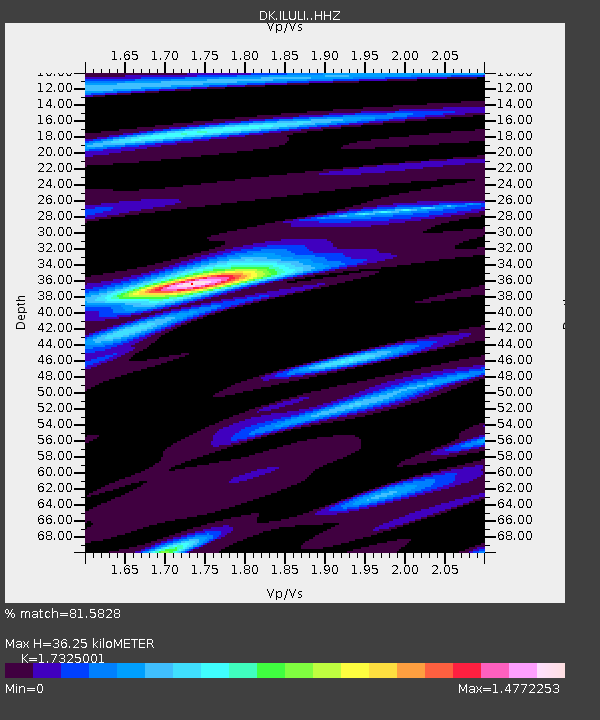
| Estimated Moho Depth: |
36.25 km |
| Estimated Crust Vp/Vs: |
1.73 |
| Assumed Crust Vp: |
6.459 km/s |
| Estimated Crust Vs: |
3.728 km/s |
| Estimated Crust Poisson's Ratio: |
0.25 |
|
| Radial Match: |
81.5828 % |
| Radial Bump: |
371 |
| Transverse Match: |
60.021584 % |
| Transverse Bump: |
400 |
| SOD ConfigId: |
7422571 |
| Insert Time: |
2019-04-20 07:13:15.840 +0000 |
| GWidth: |
2.5 |
| Max Bumps: |
400 |
| Tol: |
0.001 |
|

Signal To Noise
| Channel | StoN | STA | LTA |
| DK:ILULI: :HHZ:20150810T10:15:19.628015Z | 13.544315 | 2.1474889E-6 | 1.585528E-7 |
| DK:ILULI: :HHN:20150810T10:15:19.628015Z | 4.7449994 | 8.4636577E-7 | 1.7837006E-7 |
| DK:ILULI: :HHE:20150810T10:15:19.628015Z | 4.630114 | 7.501603E-7 | 1.6201767E-7 |
| Arrivals |
| Ps | 4.3 SECOND |
| PpPs | 15 SECOND |
| PsPs/PpSs | 19 SECOND |


