You are here: Home > Network List > TA - USArray Transportable Network (new EarthScope stations) Stations List
> Station D62A Allapoint, Allagash, ME, USA > Earthquake Result Viewer
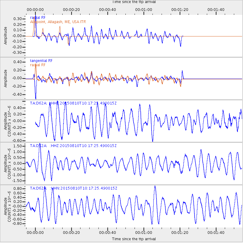
D62A Allapoint, Allagash, ME, USA - Earthquake Result Viewer
*The percent match for this event was below the threshold and hence no stack was calculated.
| Earthquake location: |
Afghanistan-Tajikistan Bord Reg. |
| Earthquake latitude/longitude: |
36.5/71.2 |
| Earthquake time(UTC): |
2015/08/10 (222) 10:05:25 GMT |
| Earthquake Depth: |
223 km |
| Earthquake Magnitude: |
5.7 MB |
| Earthquake Catalog/Contributor: |
NEIC PDE/NEIC COMCAT |
|
| Network: |
TA USArray Transportable Network (new EarthScope stations) |
| Station: |
D62A Allapoint, Allagash, ME, USA |
| Lat/Lon: |
47.08 N/69.05 W |
| Elevation: |
189 m |
|
| Distance: |
89.5 deg |
| Az: |
334.088 deg |
| Baz: |
31.003 deg |
| Ray Param: |
$rayparam |
*The percent match for this event was below the threshold and hence was not used in the summary stack. |
|
| Radial Match: |
58.319748 % |
| Radial Bump: |
328 |
| Transverse Match: |
74.954445 % |
| Transverse Bump: |
400 |
| SOD ConfigId: |
7422571 |
| Insert Time: |
2019-04-20 07:16:59.515 +0000 |
| GWidth: |
2.5 |
| Max Bumps: |
400 |
| Tol: |
0.001 |
|
Signal To Noise
| Channel | StoN | STA | LTA |
| TA:D62A: :HHZ:20150810T10:17:25.490015Z | 3.5101826 | 8.675296E-7 | 2.4714657E-7 |
| TA:D62A: :HHN:20150810T10:17:25.490015Z | 1.3821696 | 3.6775816E-7 | 2.660731E-7 |
| TA:D62A: :HHE:20150810T10:17:25.490015Z | 1.1782365 | 3.528459E-7 | 2.994695E-7 |
| Arrivals |
| Ps | |
| PpPs | |
| PsPs/PpSs | |


