You are here: Home > Network List > TA - USArray Transportable Network (new EarthScope stations) Stations List
> Station MDND Maddock, ND, USA > Earthquake Result Viewer
MDND Maddock, ND, USA - Earthquake Result Viewer
*The percent match for this event was below the threshold and hence no stack was calculated.
| Earthquake location: |
Afghanistan-Tajikistan Bord Reg. |
| Earthquake latitude/longitude: |
36.5/71.2 |
| Earthquake time(UTC): |
2015/08/10 (222) 10:05:25 GMT |
| Earthquake Depth: |
223 km |
| Earthquake Magnitude: |
5.7 MB |
| Earthquake Catalog/Contributor: |
NEIC PDE/NEIC COMCAT |
|
| Network: |
TA USArray Transportable Network (new EarthScope stations) |
| Station: |
MDND Maddock, ND, USA |
| Lat/Lon: |
47.85 N/99.60 W |
| Elevation: |
479 m |
|
| Distance: |
95.6 deg |
| Az: |
353.792 deg |
| Baz: |
7.431 deg |
| Ray Param: |
$rayparam |
*The percent match for this event was below the threshold and hence was not used in the summary stack. |
|
| Radial Match: |
58.842735 % |
| Radial Bump: |
372 |
| Transverse Match: |
68.48424 % |
| Transverse Bump: |
400 |
| SOD ConfigId: |
7422571 |
| Insert Time: |
2019-04-20 07:17:26.993 +0000 |
| GWidth: |
2.5 |
| Max Bumps: |
400 |
| Tol: |
0.001 |
|
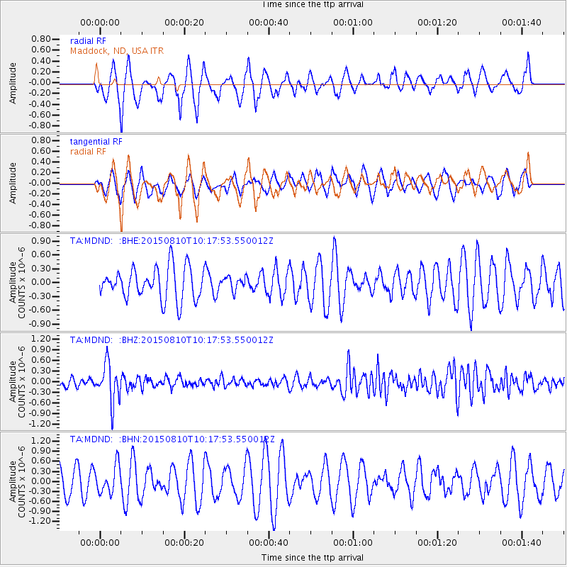
Signal To Noise
| Channel | StoN | STA | LTA |
| TA:MDND: :BHZ:20150810T10:17:53.550012Z | 4.3754077 | 5.53818E-7 | 1.2657517E-7 |
| TA:MDND: :BHN:20150810T10:17:53.550012Z | 0.86573184 | 4.2101337E-7 | 4.863092E-7 |
| TA:MDND: :BHE:20150810T10:17:53.550012Z | 0.41954648 | 1.45916E-7 | 3.477946E-7 |
| Arrivals |
| Ps | |
| PpPs | |
| PsPs/PpSs | |


