You are here: Home > Network List > UW - Pacific Northwest Regional Seismic Network Stations List
> Station MRBL Marblemount, WA, USA > Earthquake Result Viewer
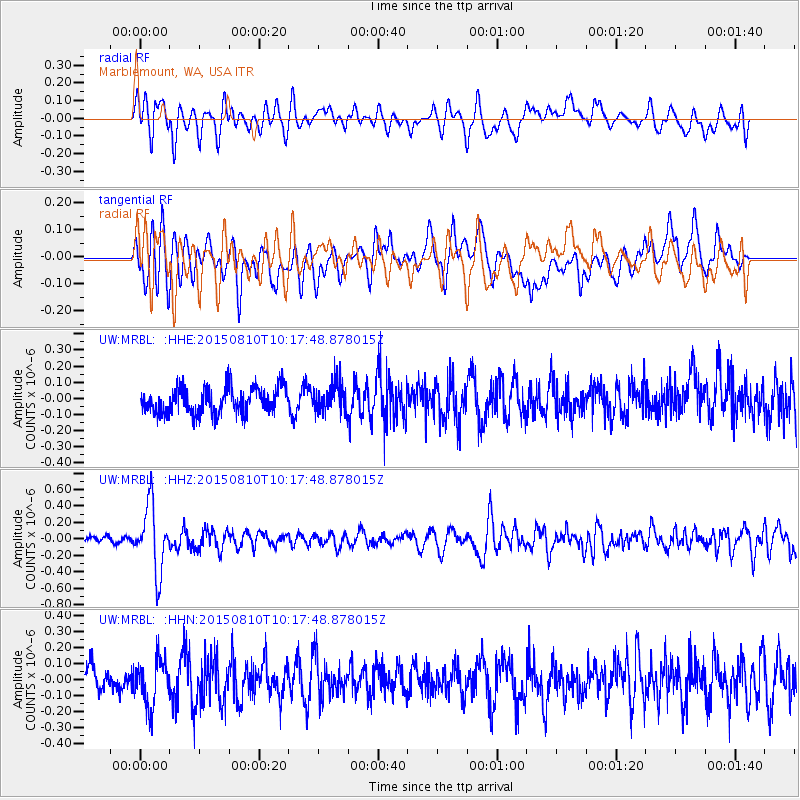
MRBL Marblemount, WA, USA - Earthquake Result Viewer
*The percent match for this event was below the threshold and hence no stack was calculated.
| Earthquake location: |
Afghanistan-Tajikistan Bord Reg. |
| Earthquake latitude/longitude: |
36.5/71.2 |
| Earthquake time(UTC): |
2015/08/10 (222) 10:05:25 GMT |
| Earthquake Depth: |
223 km |
| Earthquake Magnitude: |
5.7 MB |
| Earthquake Catalog/Contributor: |
NEIC PDE/NEIC COMCAT |
|
| Network: |
UW Pacific Northwest Regional Seismic Network |
| Station: |
MRBL Marblemount, WA, USA |
| Lat/Lon: |
48.52 N/121.48 W |
| Elevation: |
75 m |
|
| Distance: |
94.6 deg |
| Az: |
8.424 deg |
| Baz: |
349.776 deg |
| Ray Param: |
$rayparam |
*The percent match for this event was below the threshold and hence was not used in the summary stack. |
|
| Radial Match: |
61.713425 % |
| Radial Bump: |
400 |
| Transverse Match: |
58.555046 % |
| Transverse Bump: |
400 |
| SOD ConfigId: |
7422571 |
| Insert Time: |
2019-04-20 07:18:01.705 +0000 |
| GWidth: |
2.5 |
| Max Bumps: |
400 |
| Tol: |
0.001 |
|
Signal To Noise
| Channel | StoN | STA | LTA |
| UW:MRBL: :HHZ:20150810T10:17:48.878015Z | 8.816617 | 3.971116E-7 | 4.504127E-8 |
| UW:MRBL: :HHN:20150810T10:17:48.878015Z | 1.9532826 | 1.4293293E-7 | 7.3175755E-8 |
| UW:MRBL: :HHE:20150810T10:17:48.878015Z | 1.1830412 | 9.597068E-8 | 8.1122E-8 |
| Arrivals |
| Ps | |
| PpPs | |
| PsPs/PpSs | |


