You are here: Home > Network List > WY - Yellowstone Wyoming Seismic Network Stations List
> Station YHH Holmes Hill, YNP, WY, USA > Earthquake Result Viewer
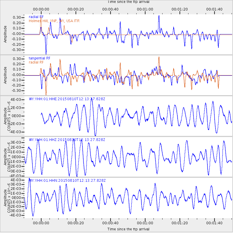
YHH Holmes Hill, YNP, WY, USA - Earthquake Result Viewer
*The percent match for this event was below the threshold and hence no stack was calculated.
| Earthquake location: |
New Britain Region, P.N.G. |
| Earthquake latitude/longitude: |
-4.9/152.5 |
| Earthquake time(UTC): |
2015/08/10 (222) 12:00:28 GMT |
| Earthquake Depth: |
55 km |
| Earthquake Magnitude: |
4.9 mb |
| Earthquake Catalog/Contributor: |
ISC/ISC |
|
| Network: |
WY Yellowstone Wyoming Seismic Network |
| Station: |
YHH Holmes Hill, YNP, WY, USA |
| Lat/Lon: |
44.79 N/110.85 W |
| Elevation: |
2717 m |
|
| Distance: |
98.2 deg |
| Az: |
45.606 deg |
| Baz: |
271.191 deg |
| Ray Param: |
$rayparam |
*The percent match for this event was below the threshold and hence was not used in the summary stack. |
|
| Radial Match: |
62.967926 % |
| Radial Bump: |
400 |
| Transverse Match: |
45.97365 % |
| Transverse Bump: |
400 |
| SOD ConfigId: |
7422571 |
| Insert Time: |
2019-04-20 07:26:07.184 +0000 |
| GWidth: |
2.5 |
| Max Bumps: |
400 |
| Tol: |
0.001 |
|
Signal To Noise
| Channel | StoN | STA | LTA |
| WY:YHH:01:HHZ:20150810T12:13:27.828Z | 1.2395965 | 1.6255676E-9 | 1.3113683E-9 |
| WY:YHH:01:HHN:20150810T12:13:27.828Z | 0.5176048 | 8.4259666E-10 | 1.6278764E-9 |
| WY:YHH:01:HHE:20150810T12:13:27.828Z | 2.1068237 | 3.0137375E-9 | 1.4304649E-9 |
| Arrivals |
| Ps | |
| PpPs | |
| PsPs/PpSs | |


