You are here: Home > Network List > TA - USArray Transportable Network (new EarthScope stations) Stations List
> Station R11A Troy Canyon, Currant, NV, USA > Earthquake Result Viewer
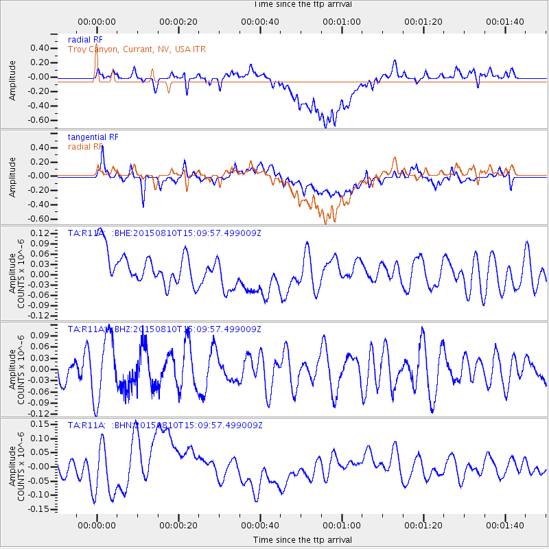
R11A Troy Canyon, Currant, NV, USA - Earthquake Result Viewer
*The percent match for this event was below the threshold and hence no stack was calculated.
| Earthquake location: |
Kuril Islands |
| Earthquake latitude/longitude: |
43.7/147.6 |
| Earthquake time(UTC): |
2015/08/10 (222) 14:59:27 GMT |
| Earthquake Depth: |
45 km |
| Earthquake Magnitude: |
4.7 mb |
| Earthquake Catalog/Contributor: |
ISC/ISC |
|
| Network: |
TA USArray Transportable Network (new EarthScope stations) |
| Station: |
R11A Troy Canyon, Currant, NV, USA |
| Lat/Lon: |
38.35 N/115.59 W |
| Elevation: |
1756 m |
|
| Distance: |
69.1 deg |
| Az: |
56.7 deg |
| Baz: |
309.541 deg |
| Ray Param: |
$rayparam |
*The percent match for this event was below the threshold and hence was not used in the summary stack. |
|
| Radial Match: |
38.915066 % |
| Radial Bump: |
400 |
| Transverse Match: |
53.82894 % |
| Transverse Bump: |
400 |
| SOD ConfigId: |
7422571 |
| Insert Time: |
2019-04-20 07:34:02.475 +0000 |
| GWidth: |
2.5 |
| Max Bumps: |
400 |
| Tol: |
0.001 |
|
Signal To Noise
| Channel | StoN | STA | LTA |
| TA:R11A: :BHZ:20150810T15:09:57.499009Z | 2.324139 | 8.816798E-8 | 3.7935763E-8 |
| TA:R11A: :BHN:20150810T15:09:57.499009Z | 1.9854329 | 8.604264E-8 | 4.333697E-8 |
| TA:R11A: :BHE:20150810T15:09:57.499009Z | 1.2139794 | 5.7014454E-8 | 4.696493E-8 |
| Arrivals |
| Ps | |
| PpPs | |
| PsPs/PpSs | |


