You are here: Home > Network List > US - United States National Seismic Network Stations List
> Station DGMT Dagmar, Montana, USA > Earthquake Result Viewer
DGMT Dagmar, Montana, USA - Earthquake Result Viewer
*The percent match for this event was below the threshold and hence no stack was calculated.
| Earthquake location: |
Kuril Islands |
| Earthquake latitude/longitude: |
43.7/147.6 |
| Earthquake time(UTC): |
2015/08/10 (222) 14:59:27 GMT |
| Earthquake Depth: |
45 km |
| Earthquake Magnitude: |
4.7 mb |
| Earthquake Catalog/Contributor: |
ISC/ISC |
|
| Network: |
US United States National Seismic Network |
| Station: |
DGMT Dagmar, Montana, USA |
| Lat/Lon: |
48.47 N/104.20 W |
| Elevation: |
0.0 m |
|
| Distance: |
68.7 deg |
| Az: |
42.705 deg |
| Baz: |
312.326 deg |
| Ray Param: |
$rayparam |
*The percent match for this event was below the threshold and hence was not used in the summary stack. |
|
| Radial Match: |
51.655235 % |
| Radial Bump: |
400 |
| Transverse Match: |
65.33292 % |
| Transverse Bump: |
400 |
| SOD ConfigId: |
7422571 |
| Insert Time: |
2019-04-20 07:34:29.241 +0000 |
| GWidth: |
2.5 |
| Max Bumps: |
400 |
| Tol: |
0.001 |
|
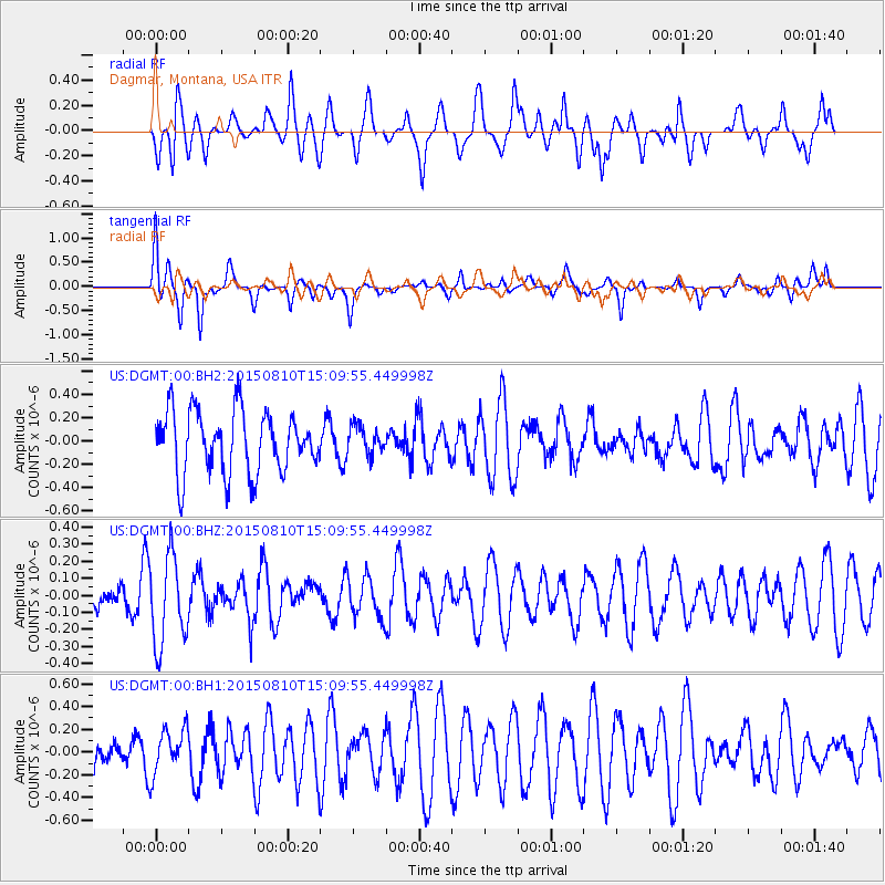
Signal To Noise
| Channel | StoN | STA | LTA |
| US:DGMT:00:BHZ:20150810T15:09:55.449998Z | 2.3873572 | 2.610045E-7 | 1.0932779E-7 |
| US:DGMT:00:BH1:20150810T15:09:55.449998Z | 1.3418976 | 1.9443245E-7 | 1.4489366E-7 |
| US:DGMT:00:BH2:20150810T15:09:55.449998Z | 0.46431595 | 1.2287603E-7 | 2.6463886E-7 |
| Arrivals |
| Ps | |
| PpPs | |
| PsPs/PpSs | |


