You are here: Home > Network List > GS - US Geological Survey Networks Stations List
> Station KAN11 Stewart Ranch, Harper County, KS, USA > Earthquake Result Viewer
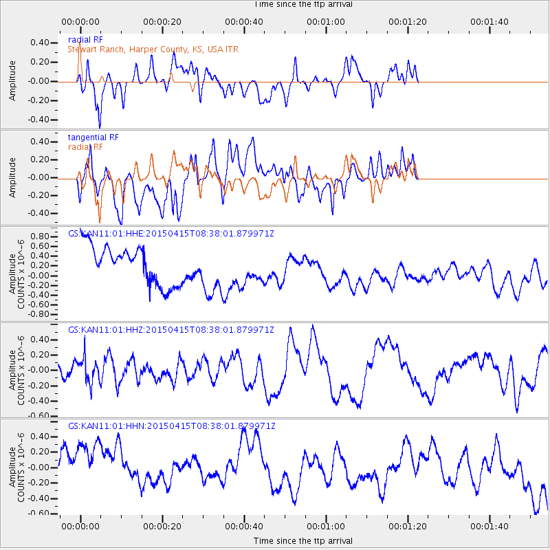
KAN11 Stewart Ranch, Harper County, KS, USA - Earthquake Result Viewer
*The percent match for this event was below the threshold and hence no stack was calculated.
| Earthquake location: |
Cyprus Region |
| Earthquake latitude/longitude: |
34.9/32.3 |
| Earthquake time(UTC): |
2015/04/15 (105) 08:25:12 GMT |
| Earthquake Depth: |
10 km |
| Earthquake Magnitude: |
5.5 MB |
| Earthquake Catalog/Contributor: |
NEIC PDE/NEIC COMCAT |
|
| Network: |
GS US Geological Survey Networks |
| Station: |
KAN11 Stewart Ranch, Harper County, KS, USA |
| Lat/Lon: |
37.21 N/97.91 W |
| Elevation: |
410 m |
|
| Distance: |
94.7 deg |
| Az: |
322.291 deg |
| Baz: |
39.046 deg |
| Ray Param: |
$rayparam |
*The percent match for this event was below the threshold and hence was not used in the summary stack. |
|
| Radial Match: |
55.361115 % |
| Radial Bump: |
400 |
| Transverse Match: |
34.70306 % |
| Transverse Bump: |
400 |
| SOD ConfigId: |
872571 |
| Insert Time: |
2015-04-29 08:37:13.870 +0000 |
| GWidth: |
2.5 |
| Max Bumps: |
400 |
| Tol: |
0.001 |
|
Signal To Noise
| Channel | StoN | STA | LTA |
| GS:KAN11:01:HHZ:20150415T08:38:01.879971Z | 1.4084188 | 1.5721825E-7 | 1.1162749E-7 |
| GS:KAN11:01:HHN:20150415T08:38:01.879971Z | 1.8853147 | 5.9559113E-7 | 3.159107E-7 |
| GS:KAN11:01:HHE:20150415T08:38:01.879971Z | 1.3751627 | 5.295127E-7 | 3.850546E-7 |
| Arrivals |
| Ps | |
| PpPs | |
| PsPs/PpSs | |


