You are here: Home > Network List > IU - Global Seismograph Network (GSN - IRIS/USGS) Stations List
> Station PMG Port Moresby, New Guinea > Earthquake Result Viewer
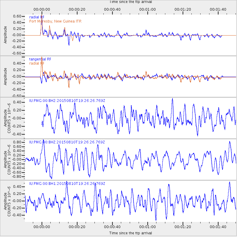
PMG Port Moresby, New Guinea - Earthquake Result Viewer
*The percent match for this event was below the threshold and hence no stack was calculated.
| Earthquake location: |
Kermadec Islands Region |
| Earthquake latitude/longitude: |
-27.3/-176.2 |
| Earthquake time(UTC): |
2015/08/10 (222) 19:19:33 GMT |
| Earthquake Depth: |
20 km |
| Earthquake Magnitude: |
5.5 MW |
| Earthquake Catalog/Contributor: |
ISC/ISC |
|
| Network: |
IU Global Seismograph Network (GSN - IRIS/USGS) |
| Station: |
PMG Port Moresby, New Guinea |
| Lat/Lon: |
9.40 S/147.16 E |
| Elevation: |
90 m |
|
| Distance: |
38.9 deg |
| Az: |
290.245 deg |
| Baz: |
122.222 deg |
| Ray Param: |
$rayparam |
*The percent match for this event was below the threshold and hence was not used in the summary stack. |
|
| Radial Match: |
60.147453 % |
| Radial Bump: |
400 |
| Transverse Match: |
56.465908 % |
| Transverse Bump: |
400 |
| SOD ConfigId: |
7422571 |
| Insert Time: |
2019-04-20 07:39:16.853 +0000 |
| GWidth: |
2.5 |
| Max Bumps: |
400 |
| Tol: |
0.001 |
|
Signal To Noise
| Channel | StoN | STA | LTA |
| IU:PMG:00:BHZ:20150810T19:26:26.769Z | 4.599114 | 5.07202E-7 | 1.10282556E-7 |
| IU:PMG:00:BH1:20150810T19:26:26.769Z | 0.98671347 | 1.204221E-7 | 1.2204364E-7 |
| IU:PMG:00:BH2:20150810T19:26:26.769Z | 1.1611414 | 2.085248E-7 | 1.7958604E-7 |
| Arrivals |
| Ps | |
| PpPs | |
| PsPs/PpSs | |


