You are here: Home > Network List > IU - Global Seismograph Network (GSN - IRIS/USGS) Stations List
> Station ADK Adak, Aleutian Islands, Alaska > Earthquake Result Viewer
ADK Adak, Aleutian Islands, Alaska - Earthquake Result Viewer
| Earthquake location: |
Off W Coast Of Northern Sumatra |
| Earthquake latitude/longitude: |
2.8/96.0 |
| Earthquake time(UTC): |
2008/02/20 (051) 08:08:30 GMT |
| Earthquake Depth: |
26 km |
| Earthquake Magnitude: |
6.5 MB, 7.5 MS, 7.4 MW, 7.4 MW |
| Earthquake Catalog/Contributor: |
WHDF/NEIC |
|
| Network: |
IU Global Seismograph Network (GSN - IRIS/USGS) |
| Station: |
ADK Adak, Aleutian Islands, Alaska |
| Lat/Lon: |
51.88 N/176.68 W |
| Elevation: |
116 m |
|
| Distance: |
86.2 deg |
| Az: |
38.355 deg |
| Baz: |
269.628 deg |
| Ray Param: |
0.044191368 |
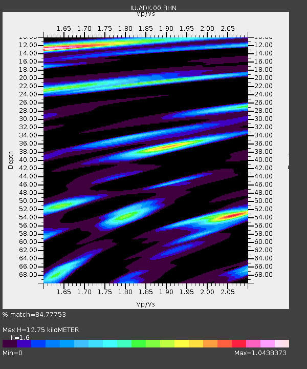
| Estimated Moho Depth: |
12.75 km |
| Estimated Crust Vp/Vs: |
1.60 |
| Assumed Crust Vp: |
5.88 km/s |
| Estimated Crust Vs: |
3.675 km/s |
| Estimated Crust Poisson's Ratio: |
0.18 |
|
| Radial Match: |
84.77753 % |
| Radial Bump: |
400 |
| Transverse Match: |
80.33741 % |
| Transverse Bump: |
400 |
| SOD ConfigId: |
2564 |
| Insert Time: |
2010-03-04 15:17:22.683 +0000 |
| GWidth: |
2.5 |
| Max Bumps: |
400 |
| Tol: |
0.001 |
|

Signal To Noise
| Channel | StoN | STA | LTA |
| IU:ADK:00:BHN:20080220T08:20:38.149028Z | 1.7831491 | 1.6373353E-6 | 9.182269E-7 |
| IU:ADK:00:BHE:20080220T08:20:38.149028Z | 1.572753 | 1.4133522E-6 | 8.986485E-7 |
| IU:ADK:00:BHZ:20080220T08:20:38.149028Z | 2.4078805 | 2.5788052E-6 | 1.0709856E-6 |
| Arrivals |
| Ps | 1.3 SECOND |
| PpPs | 5.5 SECOND |
| PsPs/PpSs | 6.8 SECOND |


