You are here: Home > Network List > UU - University of Utah Regional Network Stations List
> Station BSUT Blindstream Canyon, Hanna, UT, USA > Earthquake Result Viewer
BSUT Blindstream Canyon, Hanna, UT, USA - Earthquake Result Viewer
| Earthquake location: |
Cyprus Region |
| Earthquake latitude/longitude: |
34.9/32.3 |
| Earthquake time(UTC): |
2015/04/15 (105) 08:25:12 GMT |
| Earthquake Depth: |
10 km |
| Earthquake Magnitude: |
5.5 MB |
| Earthquake Catalog/Contributor: |
NEIC PDE/NEIC COMCAT |
|
| Network: |
UU University of Utah Regional Network |
| Station: |
BSUT Blindstream Canyon, Hanna, UT, USA |
| Lat/Lon: |
40.54 N/110.76 W |
| Elevation: |
3211 m |
|
| Distance: |
97.6 deg |
| Az: |
332.484 deg |
| Baz: |
29.898 deg |
| Ray Param: |
0.04015966 |
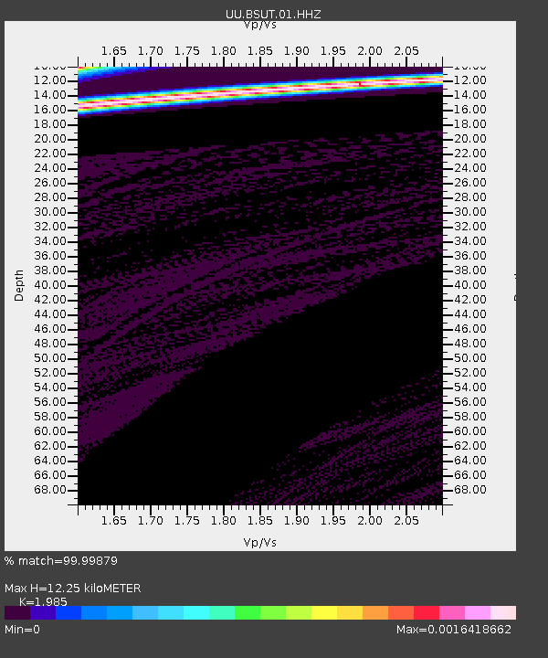
| Estimated Moho Depth: |
12.25 km |
| Estimated Crust Vp/Vs: |
1.99 |
| Assumed Crust Vp: |
6.155 km/s |
| Estimated Crust Vs: |
3.101 km/s |
| Estimated Crust Poisson's Ratio: |
0.33 |
|
| Radial Match: |
99.99879 % |
| Radial Bump: |
2 |
| Transverse Match: |
99.02979 % |
| Transverse Bump: |
16 |
| SOD ConfigId: |
872571 |
| Insert Time: |
2015-04-29 08:42:13.436 +0000 |
| GWidth: |
2.5 |
| Max Bumps: |
400 |
| Tol: |
0.001 |
|

Signal To Noise
| Channel | StoN | STA | LTA |
| UU:BSUT:01:HHZ:20150415T08:38:15.188015Z | 0.79734737 | 2.5717745E-5 | 3.225413E-5 |
| UU:BSUT:01:HHN:20150415T08:38:15.188015Z | 0.7931523 | 3.1492746E-5 | 3.97058E-5 |
| UU:BSUT:01:HHE:20150415T08:38:15.188015Z | 0.7936276 | 1.779483E-5 | 2.242214E-5 |
| Arrivals |
| Ps | 2.0 SECOND |
| PpPs | 5.8 SECOND |
| PsPs/PpSs | 7.8 SECOND |


