You are here: Home > Network List > TA - USArray Transportable Network (new EarthScope stations) Stations List
> Station A04D Lummi Island, WA, USA > Earthquake Result Viewer
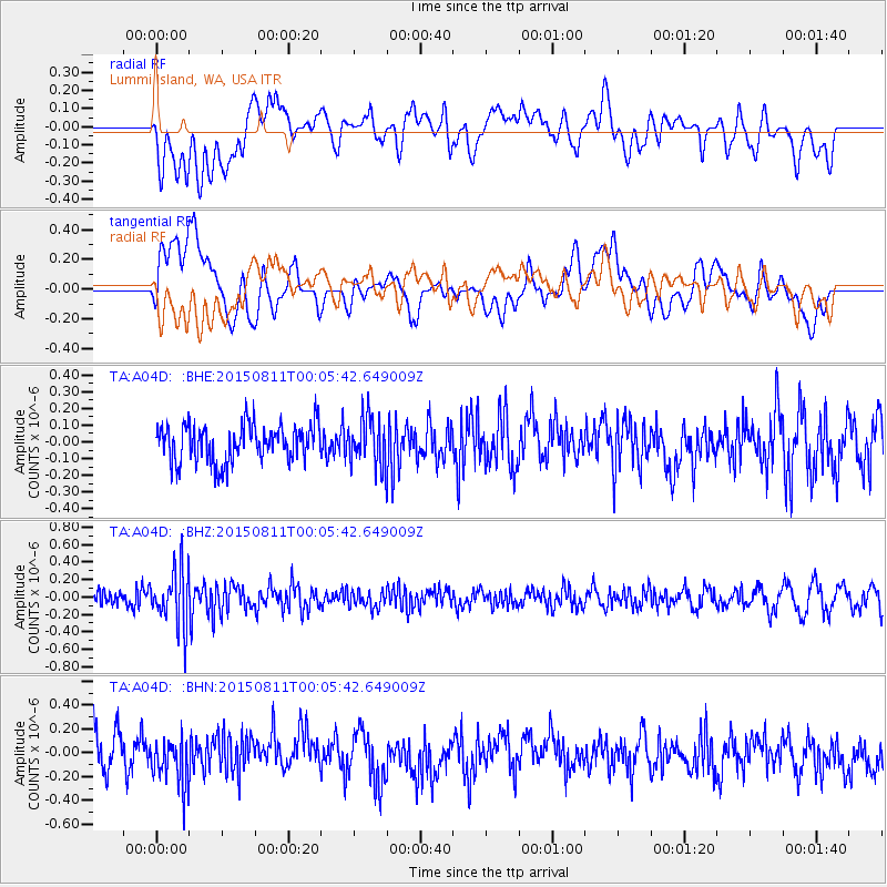
A04D Lummi Island, WA, USA - Earthquake Result Viewer
*The percent match for this event was below the threshold and hence no stack was calculated.
| Earthquake location: |
New Britain Region, P.N.G. |
| Earthquake latitude/longitude: |
-5.6/151.9 |
| Earthquake time(UTC): |
2015/08/10 (222) 23:53:14 GMT |
| Earthquake Depth: |
45 km |
| Earthquake Magnitude: |
5.3 MW |
| Earthquake Catalog/Contributor: |
ISC/ISC |
|
| Network: |
TA USArray Transportable Network (new EarthScope stations) |
| Station: |
A04D Lummi Island, WA, USA |
| Lat/Lon: |
48.72 N/122.71 W |
| Elevation: |
13 m |
|
| Distance: |
91.1 deg |
| Az: |
41.318 deg |
| Baz: |
262.905 deg |
| Ray Param: |
$rayparam |
*The percent match for this event was below the threshold and hence was not used in the summary stack. |
|
| Radial Match: |
41.302467 % |
| Radial Bump: |
400 |
| Transverse Match: |
42.48836 % |
| Transverse Bump: |
400 |
| SOD ConfigId: |
7422571 |
| Insert Time: |
2019-04-20 07:47:32.616 +0000 |
| GWidth: |
2.5 |
| Max Bumps: |
400 |
| Tol: |
0.001 |
|
Signal To Noise
| Channel | StoN | STA | LTA |
| TA:A04D: :BHZ:20150811T00:05:42.649009Z | 3.5748777 | 3.3070168E-7 | 9.250713E-8 |
| TA:A04D: :BHN:20150811T00:05:42.649009Z | 1.0740755 | 1.8512989E-7 | 1.7236209E-7 |
| TA:A04D: :BHE:20150811T00:05:42.649009Z | 1.2645744 | 1.4093783E-7 | 1.114508E-7 |
| Arrivals |
| Ps | |
| PpPs | |
| PsPs/PpSs | |


