You are here: Home > Network List > TA - USArray Transportable Network (new EarthScope stations) Stations List
> Station J20K Nowitna River, AK, USA > Earthquake Result Viewer
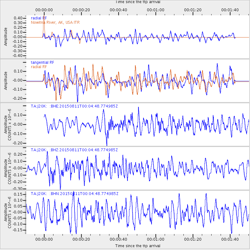
J20K Nowitna River, AK, USA - Earthquake Result Viewer
*The percent match for this event was below the threshold and hence no stack was calculated.
| Earthquake location: |
New Britain Region, P.N.G. |
| Earthquake latitude/longitude: |
-5.6/151.9 |
| Earthquake time(UTC): |
2015/08/10 (222) 23:53:14 GMT |
| Earthquake Depth: |
45 km |
| Earthquake Magnitude: |
5.3 MW |
| Earthquake Catalog/Contributor: |
ISC/ISC |
|
| Network: |
TA USArray Transportable Network (new EarthScope stations) |
| Station: |
J20K Nowitna River, AK, USA |
| Lat/Lon: |
64.18 N/154.15 W |
| Elevation: |
314 m |
|
| Distance: |
80.2 deg |
| Az: |
21.064 deg |
| Baz: |
234.766 deg |
| Ray Param: |
$rayparam |
*The percent match for this event was below the threshold and hence was not used in the summary stack. |
|
| Radial Match: |
49.452877 % |
| Radial Bump: |
391 |
| Transverse Match: |
58.051678 % |
| Transverse Bump: |
321 |
| SOD ConfigId: |
7422571 |
| Insert Time: |
2019-04-20 07:47:42.261 +0000 |
| GWidth: |
2.5 |
| Max Bumps: |
400 |
| Tol: |
0.001 |
|
Signal To Noise
| Channel | StoN | STA | LTA |
| TA:J20K: :BHZ:20150811T00:04:48.774985Z | 1.7724531 | 1.2006805E-7 | 6.774117E-8 |
| TA:J20K: :BHN:20150811T00:04:48.774985Z | 1.2942977 | 8.776734E-8 | 6.781078E-8 |
| TA:J20K: :BHE:20150811T00:04:48.774985Z | 2.012023 | 9.858611E-8 | 4.89985E-8 |
| Arrivals |
| Ps | |
| PpPs | |
| PsPs/PpSs | |


