You are here: Home > Network List > US - United States National Seismic Network Stations List
> Station HAWA Hanford, Washington, USA > Earthquake Result Viewer
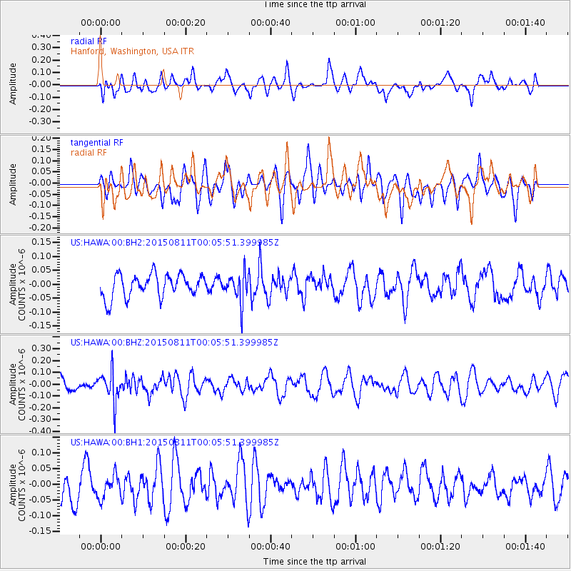
HAWA Hanford, Washington, USA - Earthquake Result Viewer
*The percent match for this event was below the threshold and hence no stack was calculated.
| Earthquake location: |
New Britain Region, P.N.G. |
| Earthquake latitude/longitude: |
-5.6/151.9 |
| Earthquake time(UTC): |
2015/08/10 (222) 23:53:14 GMT |
| Earthquake Depth: |
45 km |
| Earthquake Magnitude: |
5.3 MW |
| Earthquake Catalog/Contributor: |
ISC/ISC |
|
| Network: |
US United States National Seismic Network |
| Station: |
HAWA Hanford, Washington, USA |
| Lat/Lon: |
46.39 N/119.53 W |
| Elevation: |
364 m |
|
| Distance: |
93.0 deg |
| Az: |
43.859 deg |
| Baz: |
265.15 deg |
| Ray Param: |
$rayparam |
*The percent match for this event was below the threshold and hence was not used in the summary stack. |
|
| Radial Match: |
61.47611 % |
| Radial Bump: |
400 |
| Transverse Match: |
48.52698 % |
| Transverse Bump: |
400 |
| SOD ConfigId: |
7422571 |
| Insert Time: |
2019-04-20 07:48:23.948 +0000 |
| GWidth: |
2.5 |
| Max Bumps: |
400 |
| Tol: |
0.001 |
|
Signal To Noise
| Channel | StoN | STA | LTA |
| US:HAWA:00:BHZ:20150811T00:05:51.399985Z | 2.0356557 | 1.3003788E-7 | 6.3880094E-8 |
| US:HAWA:00:BH1:20150811T00:05:51.399985Z | 0.8107212 | 3.7474013E-8 | 4.622306E-8 |
| US:HAWA:00:BH2:20150811T00:05:51.399985Z | 1.3157456 | 5.4159866E-8 | 4.116287E-8 |
| Arrivals |
| Ps | |
| PpPs | |
| PsPs/PpSs | |


