You are here: Home > Network List > IU - Global Seismograph Network (GSN - IRIS/USGS) Stations List
> Station ADK Adak, Aleutian Islands, Alaska > Earthquake Result Viewer
ADK Adak, Aleutian Islands, Alaska - Earthquake Result Viewer
| Earthquake location: |
Tonga Islands |
| Earthquake latitude/longitude: |
-21.1/-175.5 |
| Earthquake time(UTC): |
1995/07/28 (209) 14:29:12 GMT |
| Earthquake Depth: |
102 km |
| Earthquake Magnitude: |
6.1 MB, 6.5 UNKNOWN, 6.4 MW |
| Earthquake Catalog/Contributor: |
WHDF/NEIC |
|
| Network: |
IU Global Seismograph Network (GSN - IRIS/USGS) |
| Station: |
ADK Adak, Aleutian Islands, Alaska |
| Lat/Lon: |
51.88 N/176.68 W |
| Elevation: |
116 m |
|
| Distance: |
72.7 deg |
| Az: |
359.221 deg |
| Baz: |
178.827 deg |
| Ray Param: |
0.05326247 |
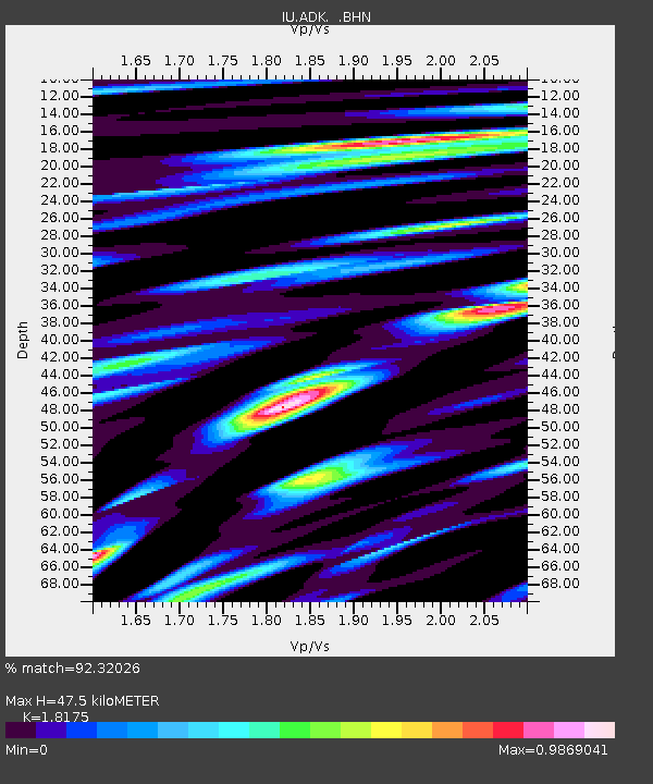
| Estimated Moho Depth: |
47.5 km |
| Estimated Crust Vp/Vs: |
1.82 |
| Assumed Crust Vp: |
5.88 km/s |
| Estimated Crust Vs: |
3.235 km/s |
| Estimated Crust Poisson's Ratio: |
0.28 |
|
| Radial Match: |
92.32026 % |
| Radial Bump: |
400 |
| Transverse Match: |
86.82922 % |
| Transverse Bump: |
400 |
| SOD ConfigId: |
6273 |
| Insert Time: |
2010-03-04 15:18:18.035 +0000 |
| GWidth: |
2.5 |
| Max Bumps: |
400 |
| Tol: |
0.001 |
|

Signal To Noise
| Channel | StoN | STA | LTA |
| IU:ADK: :BHN:19950728T14:39:58.027026Z | 23.033407 | 3.1242137E-6 | 1.3563836E-7 |
| IU:ADK: :BHE:19950728T14:39:58.027026Z | 7.4620194 | 1.1061508E-6 | 1.4823745E-7 |
| IU:ADK: :BHZ:19950728T14:39:58.027026Z | 52.20815 | 6.443882E-6 | 1.2342674E-7 |
| Arrivals |
| Ps | 6.8 SECOND |
| PpPs | 22 SECOND |
| PsPs/PpSs | 29 SECOND |


