You are here: Home > Network List > TA - USArray Transportable Network (new EarthScope stations) Stations List
> Station R11A Troy Canyon, Currant, NV, USA > Earthquake Result Viewer
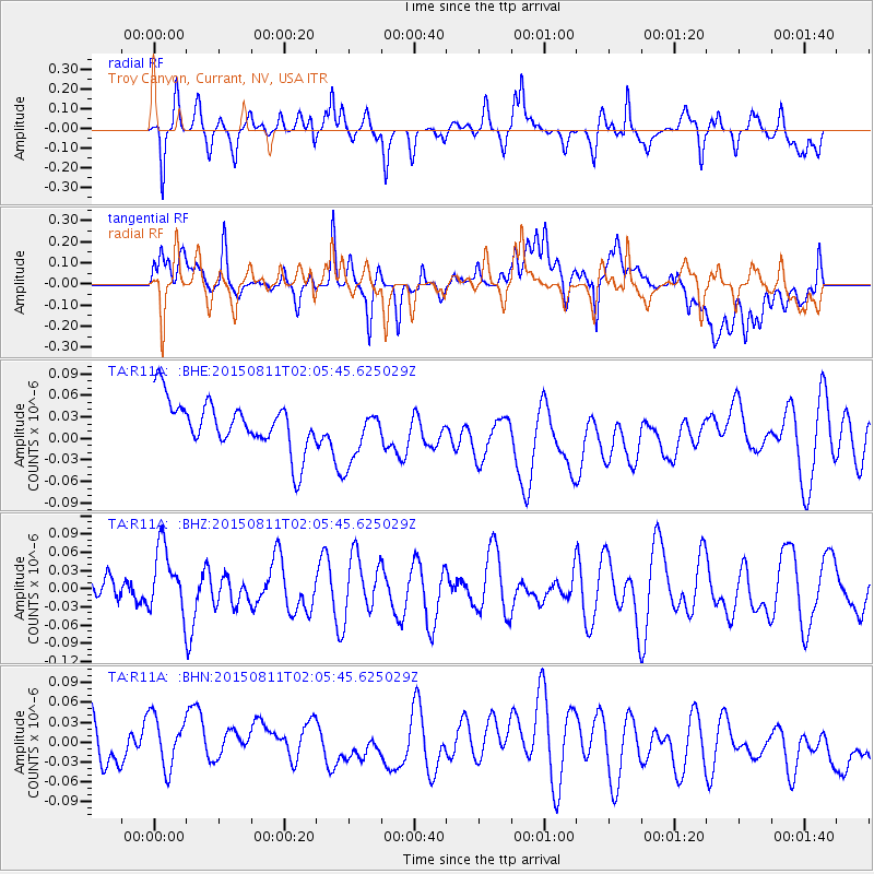
R11A Troy Canyon, Currant, NV, USA - Earthquake Result Viewer
*The percent match for this event was below the threshold and hence no stack was calculated.
| Earthquake location: |
Kermadec Islands Region |
| Earthquake latitude/longitude: |
-31.6/-177.9 |
| Earthquake time(UTC): |
2015/08/11 (223) 01:53:18 GMT |
| Earthquake Depth: |
35 km |
| Earthquake Magnitude: |
4.8 mb |
| Earthquake Catalog/Contributor: |
ISC/ISC |
|
| Network: |
TA USArray Transportable Network (new EarthScope stations) |
| Station: |
R11A Troy Canyon, Currant, NV, USA |
| Lat/Lon: |
38.35 N/115.59 W |
| Elevation: |
1756 m |
|
| Distance: |
90.6 deg |
| Az: |
44.135 deg |
| Baz: |
229.093 deg |
| Ray Param: |
$rayparam |
*The percent match for this event was below the threshold and hence was not used in the summary stack. |
|
| Radial Match: |
51.6528 % |
| Radial Bump: |
341 |
| Transverse Match: |
54.190395 % |
| Transverse Bump: |
400 |
| SOD ConfigId: |
7422571 |
| Insert Time: |
2019-04-20 07:54:02.034 +0000 |
| GWidth: |
2.5 |
| Max Bumps: |
400 |
| Tol: |
0.001 |
|
Signal To Noise
| Channel | StoN | STA | LTA |
| TA:R11A: :BHZ:20150811T02:05:45.625029Z | 1.451931 | 5.437633E-8 | 3.745104E-8 |
| TA:R11A: :BHN:20150811T02:05:45.625029Z | 1.286881 | 4.8221416E-8 | 3.7471544E-8 |
| TA:R11A: :BHE:20150811T02:05:45.625029Z | 1.1757702 | 3.9881577E-8 | 3.3919534E-8 |
| Arrivals |
| Ps | |
| PpPs | |
| PsPs/PpSs | |


