You are here: Home > Network List > IU - Global Seismograph Network (GSN - IRIS/USGS) Stations List
> Station ADK Adak, Aleutian Islands, Alaska > Earthquake Result Viewer
ADK Adak, Aleutian Islands, Alaska - Earthquake Result Viewer
| Earthquake location: |
South Of Fiji Islands |
| Earthquake latitude/longitude: |
-26.6/178.3 |
| Earthquake time(UTC): |
1997/09/04 (247) 04:23:37 GMT |
| Earthquake Depth: |
625 km |
| Earthquake Magnitude: |
6.3 MB, 6.8 UNKNOWN, 6.5 ME |
| Earthquake Catalog/Contributor: |
WHDF/NEIC |
|
| Network: |
IU Global Seismograph Network (GSN - IRIS/USGS) |
| Station: |
ADK Adak, Aleutian Islands, Alaska |
| Lat/Lon: |
51.88 N/176.68 W |
| Elevation: |
116 m |
|
| Distance: |
78.2 deg |
| Az: |
3.15 deg |
| Baz: |
184.554 deg |
| Ray Param: |
0.047791034 |
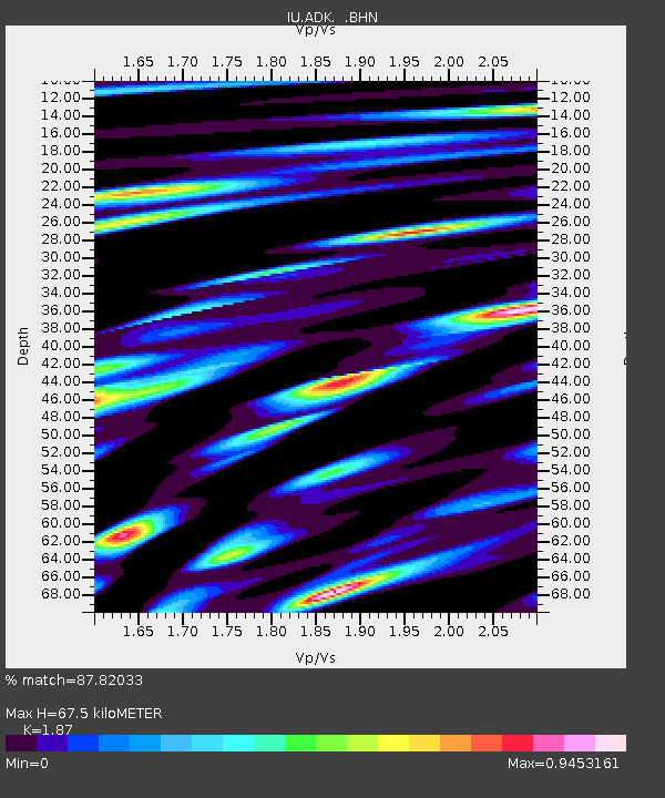
| Estimated Moho Depth: |
67.5 km |
| Estimated Crust Vp/Vs: |
1.87 |
| Assumed Crust Vp: |
5.88 km/s |
| Estimated Crust Vs: |
3.145 km/s |
| Estimated Crust Poisson's Ratio: |
0.30 |
|
| Radial Match: |
87.82033 % |
| Radial Bump: |
400 |
| Transverse Match: |
79.12304 % |
| Transverse Bump: |
400 |
| SOD ConfigId: |
6273 |
| Insert Time: |
2010-03-04 15:19:11.427 +0000 |
| GWidth: |
2.5 |
| Max Bumps: |
400 |
| Tol: |
0.001 |
|

Signal To Noise
| Channel | StoN | STA | LTA |
| IU:ADK: :BHN:19970904T04:34:02.653015Z | 9.217927 | 6.7315277E-6 | 7.3026484E-7 |
| IU:ADK: :BHE:19970904T04:34:02.653015Z | 4.311868 | 2.6328817E-6 | 6.1061274E-7 |
| IU:ADK: :BHZ:19970904T04:34:02.653015Z | 52.21418 | 1.4526223E-5 | 2.7820457E-7 |
| Arrivals |
| Ps | 10 SECOND |
| PpPs | 32 SECOND |
| PsPs/PpSs | 42 SECOND |


