You are here: Home > Network List > AV - Alaska Volcano Observatory Stations List
> Station SPCR Ckakachatna River, Mount Spurr, Alaska > Earthquake Result Viewer
SPCR Ckakachatna River, Mount Spurr, Alaska - Earthquake Result Viewer
*The percent match for this event was below the threshold and hence no stack was calculated.
| Earthquake location: |
Kermadec Islands Region |
| Earthquake latitude/longitude: |
-27.2/-176.1 |
| Earthquake time(UTC): |
2015/08/11 (223) 13:35:51 GMT |
| Earthquake Depth: |
28 km |
| Earthquake Magnitude: |
5.5 MW |
| Earthquake Catalog/Contributor: |
ISC/ISC |
|
| Network: |
AV Alaska Volcano Observatory |
| Station: |
SPCR Ckakachatna River, Mount Spurr, Alaska |
| Lat/Lon: |
61.20 N/152.21 W |
| Elevation: |
984 m |
|
| Distance: |
90.2 deg |
| Az: |
11.315 deg |
| Baz: |
201.156 deg |
| Ray Param: |
$rayparam |
*The percent match for this event was below the threshold and hence was not used in the summary stack. |
|
| Radial Match: |
44.63938 % |
| Radial Bump: |
314 |
| Transverse Match: |
54.655308 % |
| Transverse Bump: |
400 |
| SOD ConfigId: |
7422571 |
| Insert Time: |
2019-04-20 07:57:04.613 +0000 |
| GWidth: |
2.5 |
| Max Bumps: |
400 |
| Tol: |
0.001 |
|
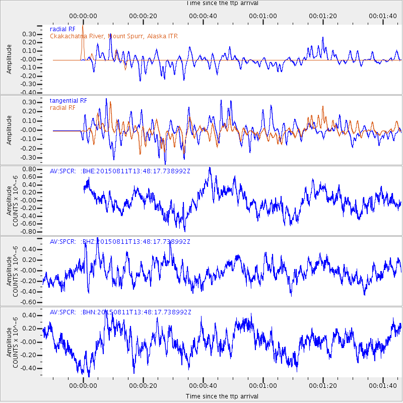
Signal To Noise
| Channel | StoN | STA | LTA |
| AV:SPCR: :BHZ:20150811T13:48:17.738992Z | 1.5199867 | 2.9193566E-7 | 1.920646E-7 |
| AV:SPCR: :BHN:20150811T13:48:17.738992Z | 3.1300912 | 3.7646294E-7 | 1.2027219E-7 |
| AV:SPCR: :BHE:20150811T13:48:17.738992Z | 2.5606017 | 4.8946373E-7 | 1.9115184E-7 |
| Arrivals |
| Ps | |
| PpPs | |
| PsPs/PpSs | |


