You are here: Home > Network List > IU - Global Seismograph Network (GSN - IRIS/USGS) Stations List
> Station ADK Adak, Aleutian Islands, Alaska > Earthquake Result Viewer
ADK Adak, Aleutian Islands, Alaska - Earthquake Result Viewer
| Earthquake location: |
New Britain Region, P.N.G. |
| Earthquake latitude/longitude: |
-4.5/150.0 |
| Earthquake time(UTC): |
2000/05/08 (129) 10:28:25 GMT |
| Earthquake Depth: |
502 km |
| Earthquake Magnitude: |
5.7 MB, 6.1 MW, 6.1 MW |
| Earthquake Catalog/Contributor: |
WHDF/NEIC |
|
| Network: |
IU Global Seismograph Network (GSN - IRIS/USGS) |
| Station: |
ADK Adak, Aleutian Islands, Alaska |
| Lat/Lon: |
51.88 N/176.68 W |
| Elevation: |
116 m |
|
| Distance: |
62.9 deg |
| Az: |
22.486 deg |
| Baz: |
217.966 deg |
| Ray Param: |
0.058106445 |
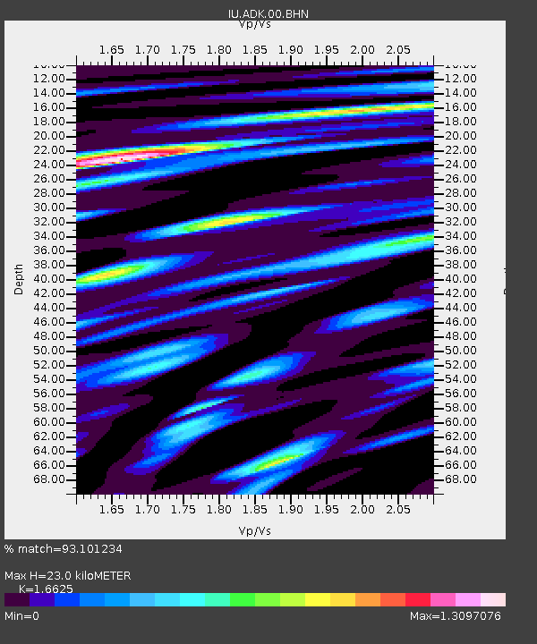
| Estimated Moho Depth: |
23.0 km |
| Estimated Crust Vp/Vs: |
1.66 |
| Assumed Crust Vp: |
5.88 km/s |
| Estimated Crust Vs: |
3.537 km/s |
| Estimated Crust Poisson's Ratio: |
0.22 |
|
| Radial Match: |
93.101234 % |
| Radial Bump: |
400 |
| Transverse Match: |
90.79228 % |
| Transverse Bump: |
400 |
| SOD ConfigId: |
3744 |
| Insert Time: |
2010-03-04 15:20:08.952 +0000 |
| GWidth: |
2.5 |
| Max Bumps: |
400 |
| Tol: |
0.001 |
|

Signal To Noise
| Channel | StoN | STA | LTA |
| IU:ADK:00:BHN:20000508T10:37:30.785002Z | 15.818177 | 1.6440094E-6 | 1.0393166E-7 |
| IU:ADK:00:BHE:20000508T10:37:30.785002Z | 10.524731 | 1.0068914E-6 | 9.566909E-8 |
| IU:ADK:00:BHZ:20000508T10:37:30.785002Z | 23.163301 | 4.3027576E-6 | 1.8575753E-7 |
| Arrivals |
| Ps | 2.7 SECOND |
| PpPs | 10 SECOND |
| PsPs/PpSs | 13 SECOND |


