You are here: Home > Network List > US - United States National Seismic Network Stations List
> Station MNTX Cornudas Mountains, Texas, USA > Earthquake Result Viewer
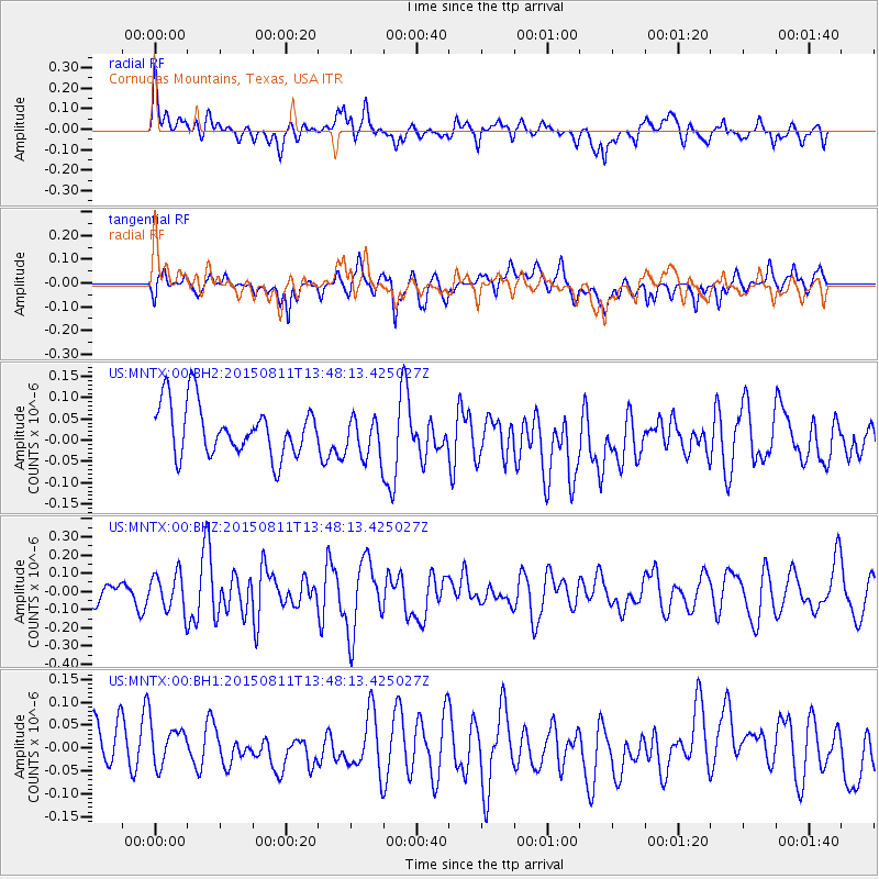
MNTX Cornudas Mountains, Texas, USA - Earthquake Result Viewer
*The percent match for this event was below the threshold and hence no stack was calculated.
| Earthquake location: |
Kermadec Islands Region |
| Earthquake latitude/longitude: |
-27.2/-176.1 |
| Earthquake time(UTC): |
2015/08/11 (223) 13:35:51 GMT |
| Earthquake Depth: |
28 km |
| Earthquake Magnitude: |
5.5 MW |
| Earthquake Catalog/Contributor: |
ISC/ISC |
|
| Network: |
US United States National Seismic Network |
| Station: |
MNTX Cornudas Mountains, Texas, USA |
| Lat/Lon: |
31.70 N/105.38 W |
| Elevation: |
404 m |
|
| Distance: |
89.3 deg |
| Az: |
53.581 deg |
| Baz: |
237.236 deg |
| Ray Param: |
$rayparam |
*The percent match for this event was below the threshold and hence was not used in the summary stack. |
|
| Radial Match: |
57.58165 % |
| Radial Bump: |
400 |
| Transverse Match: |
43.7072 % |
| Transverse Bump: |
400 |
| SOD ConfigId: |
7422571 |
| Insert Time: |
2019-04-20 08:01:40.629 +0000 |
| GWidth: |
2.5 |
| Max Bumps: |
400 |
| Tol: |
0.001 |
|
Signal To Noise
| Channel | StoN | STA | LTA |
| US:MNTX:00:BHZ:20150811T13:48:13.425027Z | 1.883123 | 1.0286049E-7 | 5.4622287E-8 |
| US:MNTX:00:BH1:20150811T13:48:13.425027Z | 0.8084671 | 5.260205E-8 | 6.506394E-8 |
| US:MNTX:00:BH2:20150811T13:48:13.425027Z | 0.82378966 | 4.9629886E-8 | 6.0245824E-8 |
| Arrivals |
| Ps | |
| PpPs | |
| PsPs/PpSs | |


