You are here: Home > Network List > UW - Pacific Northwest Regional Seismic Network Stations List
> Station UMAT Pilot Rock, OR, USA > Earthquake Result Viewer
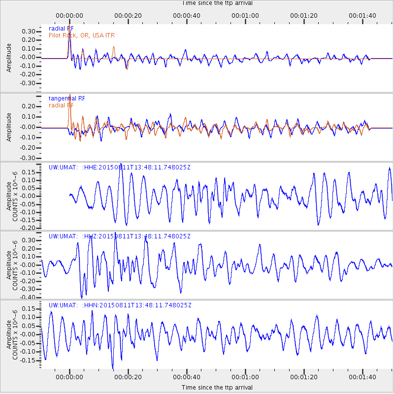
UMAT Pilot Rock, OR, USA - Earthquake Result Viewer
*The percent match for this event was below the threshold and hence no stack was calculated.
| Earthquake location: |
Kermadec Islands Region |
| Earthquake latitude/longitude: |
-27.2/-176.1 |
| Earthquake time(UTC): |
2015/08/11 (223) 13:35:51 GMT |
| Earthquake Depth: |
28 km |
| Earthquake Magnitude: |
5.5 MW |
| Earthquake Catalog/Contributor: |
ISC/ISC |
|
| Network: |
UW Pacific Northwest Regional Seismic Network |
| Station: |
UMAT Pilot Rock, OR, USA |
| Lat/Lon: |
45.29 N/118.96 W |
| Elevation: |
1318 m |
|
| Distance: |
88.9 deg |
| Az: |
36.38 deg |
| Baz: |
228.457 deg |
| Ray Param: |
$rayparam |
*The percent match for this event was below the threshold and hence was not used in the summary stack. |
|
| Radial Match: |
63.487034 % |
| Radial Bump: |
400 |
| Transverse Match: |
38.04265 % |
| Transverse Bump: |
363 |
| SOD ConfigId: |
7422571 |
| Insert Time: |
2019-04-20 08:01:57.424 +0000 |
| GWidth: |
2.5 |
| Max Bumps: |
400 |
| Tol: |
0.001 |
|
Signal To Noise
| Channel | StoN | STA | LTA |
| UW:UMAT: :HHZ:20150811T13:48:11.748025Z | 2.8640542 | 1.8196995E-7 | 6.353579E-8 |
| UW:UMAT: :HHN:20150811T13:48:11.748025Z | 0.9188602 | 5.1959326E-8 | 5.6547584E-8 |
| UW:UMAT: :HHE:20150811T13:48:11.748025Z | 0.7992375 | 6.693781E-8 | 8.3752084E-8 |
| Arrivals |
| Ps | |
| PpPs | |
| PsPs/PpSs | |


