You are here: Home > Network List > TA - USArray Transportable Network (new EarthScope stations) Stations List
> Station O03E Paynes Creek, CA, USA > Earthquake Result Viewer
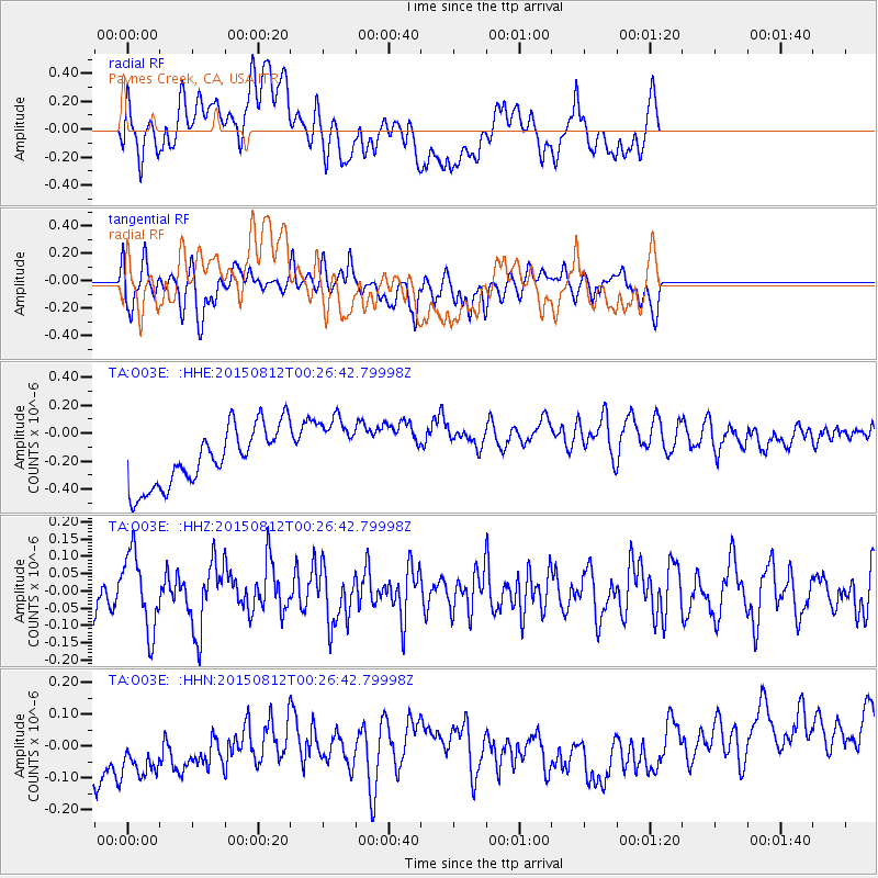
O03E Paynes Creek, CA, USA - Earthquake Result Viewer
*The percent match for this event was below the threshold and hence no stack was calculated.
| Earthquake location: |
Near Coast Of Central Chile |
| Earthquake latitude/longitude: |
-31.7/-71.6 |
| Earthquake time(UTC): |
2015/08/12 (224) 00:14:40 GMT |
| Earthquake Depth: |
30 km |
| Earthquake Magnitude: |
5.5 MWW, 5.3 MWR, 5.4 MWB |
| Earthquake Catalog/Contributor: |
NEIC PDE/NEIC COMCAT |
|
| Network: |
TA USArray Transportable Network (new EarthScope stations) |
| Station: |
O03E Paynes Creek, CA, USA |
| Lat/Lon: |
40.29 N/121.80 W |
| Elevation: |
967 m |
|
| Distance: |
85.4 deg |
| Az: |
323.887 deg |
| Baz: |
138.941 deg |
| Ray Param: |
$rayparam |
*The percent match for this event was below the threshold and hence was not used in the summary stack. |
|
| Radial Match: |
13.7181225 % |
| Radial Bump: |
400 |
| Transverse Match: |
47.824802 % |
| Transverse Bump: |
400 |
| SOD ConfigId: |
7422571 |
| Insert Time: |
2019-04-20 08:12:50.748 +0000 |
| GWidth: |
2.5 |
| Max Bumps: |
400 |
| Tol: |
0.001 |
|
Signal To Noise
| Channel | StoN | STA | LTA |
| TA:O03E: :HHZ:20150812T00:26:42.79998Z | 1.5149374 | 1.1048025E-7 | 7.292727E-8 |
| TA:O03E: :HHN:20150812T00:26:42.79998Z | 1.0715071 | 1.9900988E-7 | 1.8572894E-7 |
| TA:O03E: :HHE:20150812T00:26:42.79998Z | 1.1296638 | 2.34492E-7 | 2.0757679E-7 |
| Arrivals |
| Ps | |
| PpPs | |
| PsPs/PpSs | |


