You are here: Home > Network List > IU - Global Seismograph Network (GSN - IRIS/USGS) Stations List
> Station PMG Port Moresby, New Guinea > Earthquake Result Viewer
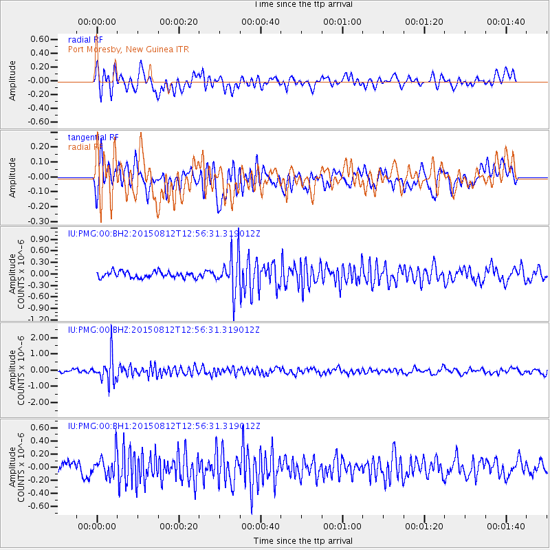
PMG Port Moresby, New Guinea - Earthquake Result Viewer
*The percent match for this event was below the threshold and hence no stack was calculated.
| Earthquake location: |
Fiji Islands Region |
| Earthquake latitude/longitude: |
-16.5/-177.3 |
| Earthquake time(UTC): |
2015/08/12 (224) 12:50:43 GMT |
| Earthquake Depth: |
415 km |
| Earthquake Magnitude: |
5.3 MW |
| Earthquake Catalog/Contributor: |
ISC/ISC |
|
| Network: |
IU Global Seismograph Network (GSN - IRIS/USGS) |
| Station: |
PMG Port Moresby, New Guinea |
| Lat/Lon: |
9.40 S/147.16 E |
| Elevation: |
90 m |
|
| Distance: |
35.3 deg |
| Az: |
277.01 deg |
| Baz: |
105.199 deg |
| Ray Param: |
$rayparam |
*The percent match for this event was below the threshold and hence was not used in the summary stack. |
|
| Radial Match: |
69.68472 % |
| Radial Bump: |
400 |
| Transverse Match: |
55.04189 % |
| Transverse Bump: |
400 |
| SOD ConfigId: |
7422571 |
| Insert Time: |
2019-04-20 08:19:51.781 +0000 |
| GWidth: |
2.5 |
| Max Bumps: |
400 |
| Tol: |
0.001 |
|
Signal To Noise
| Channel | StoN | STA | LTA |
| IU:PMG:00:BHZ:20150812T12:56:31.319012Z | 11.969833 | 8.3825364E-7 | 7.003052E-8 |
| IU:PMG:00:BH1:20150812T12:56:31.319012Z | 1.5107043 | 1.7867764E-7 | 1.1827439E-7 |
| IU:PMG:00:BH2:20150812T12:56:31.319012Z | 6.1137815 | 4.943511E-7 | 8.0858484E-8 |
| Arrivals |
| Ps | |
| PpPs | |
| PsPs/PpSs | |


