You are here: Home > Network List > TA - USArray Transportable Network (new EarthScope stations) Stations List
> Station J04D Umpqua National Forest, Toketee, OR, USA > Earthquake Result Viewer
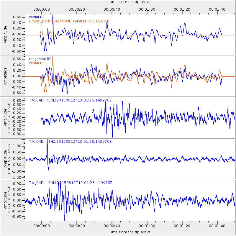
J04D Umpqua National Forest, Toketee, OR, USA - Earthquake Result Viewer
*The percent match for this event was below the threshold and hence no stack was calculated.
| Earthquake location: |
Fiji Islands Region |
| Earthquake latitude/longitude: |
-16.5/-177.3 |
| Earthquake time(UTC): |
2015/08/12 (224) 12:50:43 GMT |
| Earthquake Depth: |
415 km |
| Earthquake Magnitude: |
5.3 MW |
| Earthquake Catalog/Contributor: |
ISC/ISC |
|
| Network: |
TA USArray Transportable Network (new EarthScope stations) |
| Station: |
J04D Umpqua National Forest, Toketee, OR, USA |
| Lat/Lon: |
43.24 N/122.11 W |
| Elevation: |
1948 m |
|
| Distance: |
78.0 deg |
| Az: |
37.815 deg |
| Baz: |
233.602 deg |
| Ray Param: |
$rayparam |
*The percent match for this event was below the threshold and hence was not used in the summary stack. |
|
| Radial Match: |
63.8888 % |
| Radial Bump: |
400 |
| Transverse Match: |
59.163208 % |
| Transverse Bump: |
400 |
| SOD ConfigId: |
7422571 |
| Insert Time: |
2019-04-20 08:22:10.247 +0000 |
| GWidth: |
2.5 |
| Max Bumps: |
400 |
| Tol: |
0.001 |
|
Signal To Noise
| Channel | StoN | STA | LTA |
| TA:J04D: :BHZ:20150812T13:01:26.149976Z | 5.8440776 | 4.562716E-7 | 7.8074194E-8 |
| TA:J04D: :BHN:20150812T13:01:26.149976Z | 1.8216145 | 2.2945869E-7 | 1.2596446E-7 |
| TA:J04D: :BHE:20150812T13:01:26.149976Z | 1.642205 | 2.1814749E-7 | 1.3283817E-7 |
| Arrivals |
| Ps | |
| PpPs | |
| PsPs/PpSs | |


