You are here: Home > Network List > TA - USArray Transportable Network (new EarthScope stations) Stations List
> Station MSTX Muleshoe, TX, USA > Earthquake Result Viewer
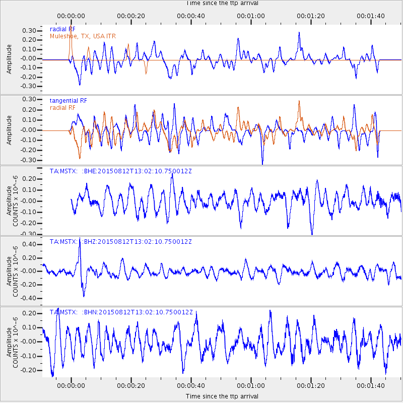
MSTX Muleshoe, TX, USA - Earthquake Result Viewer
*The percent match for this event was below the threshold and hence no stack was calculated.
| Earthquake location: |
Fiji Islands Region |
| Earthquake latitude/longitude: |
-16.5/-177.3 |
| Earthquake time(UTC): |
2015/08/12 (224) 12:50:43 GMT |
| Earthquake Depth: |
415 km |
| Earthquake Magnitude: |
5.3 MW |
| Earthquake Catalog/Contributor: |
ISC/ISC |
|
| Network: |
TA USArray Transportable Network (new EarthScope stations) |
| Station: |
MSTX Muleshoe, TX, USA |
| Lat/Lon: |
33.97 N/102.77 W |
| Elevation: |
1167 m |
|
| Distance: |
86.8 deg |
| Az: |
53.327 deg |
| Baz: |
247.804 deg |
| Ray Param: |
$rayparam |
*The percent match for this event was below the threshold and hence was not used in the summary stack. |
|
| Radial Match: |
51.605747 % |
| Radial Bump: |
400 |
| Transverse Match: |
51.002754 % |
| Transverse Bump: |
400 |
| SOD ConfigId: |
7422571 |
| Insert Time: |
2019-04-20 08:22:23.292 +0000 |
| GWidth: |
2.5 |
| Max Bumps: |
400 |
| Tol: |
0.001 |
|
Signal To Noise
| Channel | StoN | STA | LTA |
| TA:MSTX: :BHZ:20150812T13:02:10.750012Z | 2.2467167 | 1.9981061E-7 | 8.89345E-8 |
| TA:MSTX: :BHN:20150812T13:02:10.750012Z | 0.9880405 | 7.712162E-8 | 7.8055116E-8 |
| TA:MSTX: :BHE:20150812T13:02:10.750012Z | 1.5045385 | 1.2225031E-7 | 8.125436E-8 |
| Arrivals |
| Ps | |
| PpPs | |
| PsPs/PpSs | |


