You are here: Home > Network List > UW - Pacific Northwest Regional Seismic Network Stations List
> Station LEBA Lebam, WA, USA > Earthquake Result Viewer
LEBA Lebam, WA, USA - Earthquake Result Viewer
*The percent match for this event was below the threshold and hence no stack was calculated.
| Earthquake location: |
Fiji Islands Region |
| Earthquake latitude/longitude: |
-16.5/-177.3 |
| Earthquake time(UTC): |
2015/08/12 (224) 12:50:43 GMT |
| Earthquake Depth: |
415 km |
| Earthquake Magnitude: |
5.3 MW |
| Earthquake Catalog/Contributor: |
ISC/ISC |
|
| Network: |
UW Pacific Northwest Regional Seismic Network |
| Station: |
LEBA Lebam, WA, USA |
| Lat/Lon: |
46.55 N/123.56 W |
| Elevation: |
73 m |
|
| Distance: |
79.2 deg |
| Az: |
34.492 deg |
| Baz: |
231.921 deg |
| Ray Param: |
$rayparam |
*The percent match for this event was below the threshold and hence was not used in the summary stack. |
|
| Radial Match: |
66.8359 % |
| Radial Bump: |
400 |
| Transverse Match: |
56.075104 % |
| Transverse Bump: |
400 |
| SOD ConfigId: |
7422571 |
| Insert Time: |
2019-04-20 08:23:45.020 +0000 |
| GWidth: |
2.5 |
| Max Bumps: |
400 |
| Tol: |
0.001 |
|
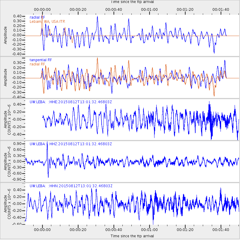
Signal To Noise
| Channel | StoN | STA | LTA |
| UW:LEBA: :HHZ:20150812T13:01:32.46803Z | 2.9984653 | 3.234091E-7 | 1.07858206E-7 |
| UW:LEBA: :HHN:20150812T13:01:32.46803Z | 0.93788165 | 1.8675507E-7 | 1.9912434E-7 |
| UW:LEBA: :HHE:20150812T13:01:32.46803Z | 1.4490483 | 1.9681637E-7 | 1.3582458E-7 |
| Arrivals |
| Ps | |
| PpPs | |
| PsPs/PpSs | |


